
Editor’s Note: This is the fourth and final part of a series the Kenai National Wildlife Refuge is doing on the history of remote sensing and aerial photography for Refuge Notebook.
As we taxi down the Soldotna airport runway in a Super Cub, I get ready to take off on another remote sensing mission. I double-check the camera settings and ensure the cameras are working and the images look good.
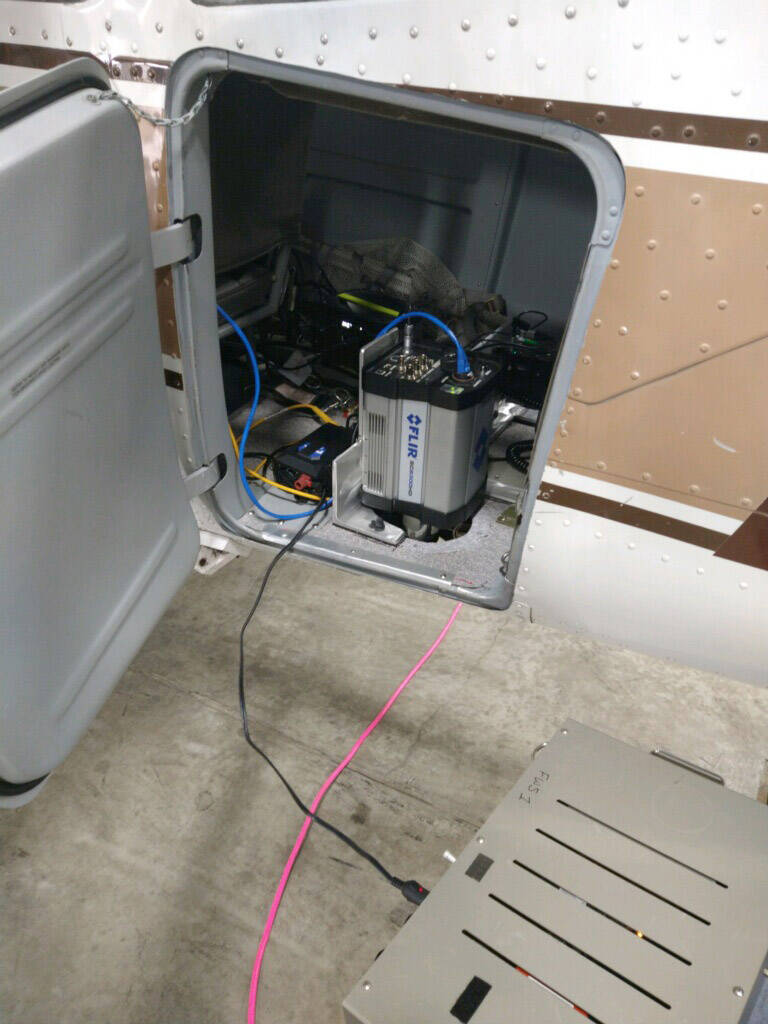
The colorful thermal image on my laptop is captured by one of the cameras attached to the belly of the Cub. It’s a Medium Wave Infrared High-Speed Science-Grade camera that can detect thermal infrared heat signatures and record thermal images up to 124 frames per second.
The other camera next to the infrared camera is a specialized photogrammetric camera built specifically for remote sensing missions like this one. This camera takes high-resolution color photos that we can use in various mapping applications.
The pilot begins to enter the airstrip and asks, “Are you good to go?” I respond, “Good to go,” and we begin to pick up speed, faster and faster, until I feel that sensation of floating as we take off from the airstrip. I look out the plane’s window and watch as the trees get smaller and smaller as we gain altitude.
As we fly over the Kenai River, I see boats in the river, and scores of fishermen line the banks below. It is July, the month when fishermen come from all over the world to fish for Pacific salmon that migrate up this river annually as they have for thousands of years.
The reason I am in the air today is because of these salmon. U.S. Fish and Wildlife Service biologists developed this remote sensing project to address concerns related to climate change that may affect salmon survival rates in the future.
The plan for the project is to conduct thermal imaging flights once a week over the summer season to gather thermal water temperature data in the form of thermal infrared images on the Funny and Moose rivers. The thermal camera on the plane detects infrared wavelengths in the mid-infrared range, also known as thermal infrared.
The infrared camera sensor will detect thermal heat signatures from the Earth’s surface and show up on the camera’s image in various colors depending on the radiation emitted from that object.
For example, a thermal image of a body of water in Alaska will typically show a dark color like blue or purple. In contrast, because of its higher temperature, the surrounding vegetation will appear in lighter colors, typically orange and red.
When the photos are processed and made into a thermal mosaic map, it becomes easy to see the differences in temperature by the various shades of light and dark colors. A specialized photogrammetry SfM (Structure for Motion) software program will then combine these images to produce a thermal map of the whole river. The final map produced is a mosaic of thousands of images.
As we fly over the Funny River, I look out the window and see green spruce trees flanking the solid blue ribbon of the river. When I turn to the computer, the trees’ heat signature shows up in orange and red gradients, and the river water is displayed in darker blue gradients.
We can compare data from these maps to data collected by temperature data loggers placed in the river by fisheries biologists from the Kenai Fish and Wildlife Conservation Office to understand how water temperature changes over time and to evaluate the accuracy and utility of the system.
Ultimately, data from data loggers and thermal imagery maps helps fisheries biologists understand how salmon respond to relatively warm or cold water.
In addition to collecting water temperature information, several salmon were captured and outfitted with radio telemetry tags. The project aims to collect stream temperature and salmon movement data over an entire summer and fall season to test new technologies and gather data on salmon movement relative to water temperature.
Back in the plane, Dom Watts, refuge pilot biologist, skillfully pilots the Cub, dodging a few small clouds as he prepares to steady the plane at an altitude of 3,300 feet. Then, we begin the flight line, where the cameras will record a thermal image and color photo every second.
Precise camera locations of these photos will be recorded by a GPS receiver that will log the position of every photo frame taken during the flight. I continue to ensure both cameras collect and store photos on the laptop’s hard drive.
The mission takes about three and a half hours, and by that time, I am done. I am ready to stretch my legs, to say the least. Anyone who has flown in the back seat of a Super Cub knows there is little space to move.
I have the laptop on my lap and an iPad with flight maps on my left side. Later, Mark Laker, the refuge’s lead remote sensing scientist on the project, will take the thousands of images captured by the cameras and create a single continuous thermal map of the river.
Mark is one of a few natural resource remote sensing experts in Alaska. For more than 30 years, he has also conducted extensive ecological research as a biologist.
Mark is also a Department of the Interior drone pilot and instructor. He has undertaken aerial photography flights by drone and fixed wing from as far away as the Arctic Refuge in northern Alaska to Izembek Refuge on the Alaska Peninsula.
He is based out of the Kenai refuge office and has led numerous natural resource mapping flights over the Kenai Peninsula. I have gained a tremendous amount of knowledge about aerial photography and remote sensing by having the fortunate opportunity to work with him this summer.
Many different types of remote sensing activities have been conducted over the years in Alaska’s remote and diverse terrain, from the high Arctic coastal plains to the vast interior mountain ranges to Alaska’s remote coastlines. Today, remote sensing project flights, like the one I am flying, continue throughout the state of Alaska. These remote sensing projects are as diverse as Alaska’s landscape.
On the Kenai refuge, these projects include everything from recording thermal images of rivers like we are doing on this flight to capturing thermal images of sea otters on the coast to mapping habitat types on the Kenai Peninsula.
Remote sensing continues to be a valuable tool that natural resource managers and scientists can use to “get a sense” from the skies above of the dynamic processes of the Earth below. This “remotely sensed” data can be used to inform agencies like the Fish and Wildlife Service on how best to conserve and manage those natural resources most Alaskans hold so dear.
Today, with the emergence of drones, satellites and high-tech digital cameras, the uses of remote sensing for geographical investigation are boundless.
As Dom navigates our Cub back to Refuge Headquarters, I turn off the laptop and tighten my seat belt to prepare for landing at the Soldotna airstrip, which is getting closer as we drop altitude and prepare to land. I enjoy the flight back as I relax and think about what a joy it is to fly on a beautiful calm day like today, where one can take in the beauty of the refuge’s backyard with a bird’s eye view.
I have flown in helicopters and small Bush planes over many remote areas of Alaska, and I am always in awe of the sheer magnitude of Alaska’s pristine wilderness.
Today even though camera technology and planes are quite a bit more advanced than 100 years ago, the mission remains the same: To take to the skies above with a camera in hand to explore the land below in the hope of capturing some of its essences.
As the old photography saying goes, “A picture is worth a thousand words!”
Dave Merz is a seasonal biological science technician on the Kenai National Wildlife Refuge who is part of a team working on using aerial photography and remote sensing to understand changing environmental conditions on the Refuge and throughout Alaska. Find more Refuge Notebook articles (1999–present) at https://www.fws.gov/kenai-refuge-notebook.
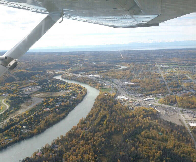
Aerial photo of the Kenai River in Alaska. (Photo by Dave Merz/FWS)
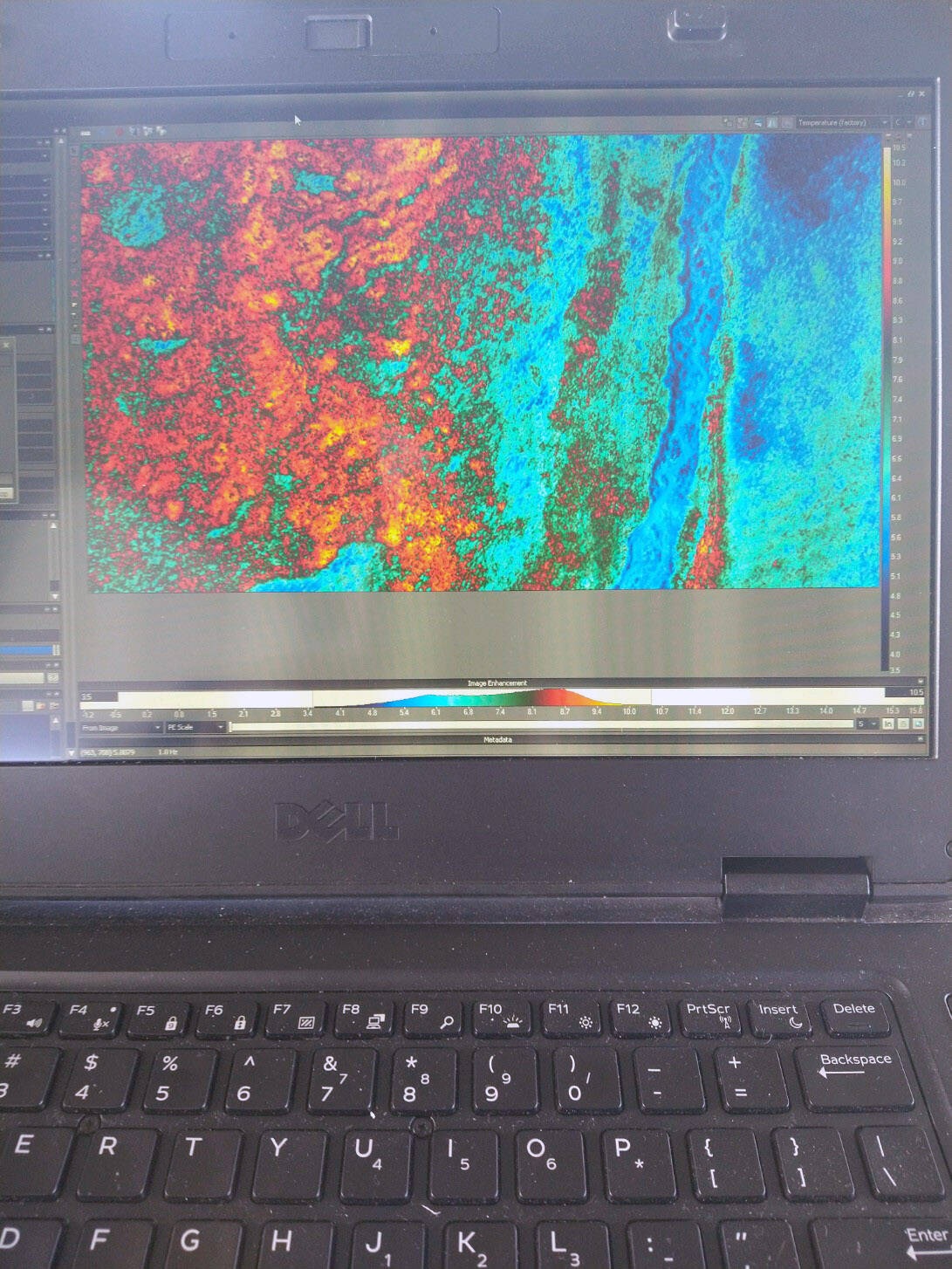
Thermal Image of Moose River on the Kenai National Wildlife Refuge in Alaska. (Photo by Dave Merz/FWS)
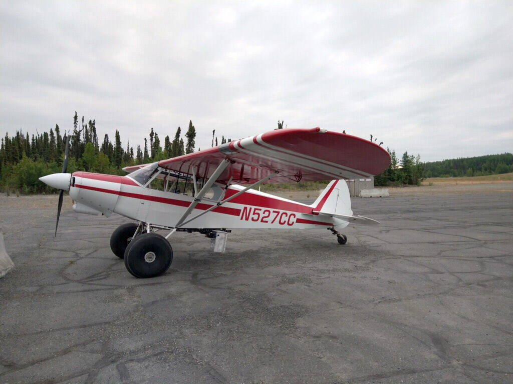
One of the planes used on remote sensing missions. (Photo by Dave Merz/FWS)
