
Editor’s note: This story has been updated to mention AGDC’s Feb. 19 meeting with the Nikiski Community Council.
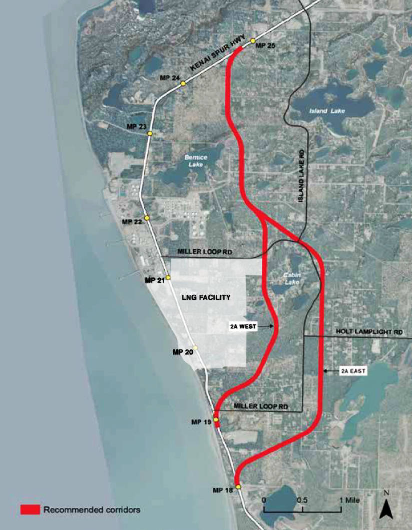
The Alaska Gasline Development Corporation has tentatively selected two final alternatives for rerouting the Kenai Spur Highway around the natural gas liquefaction and export terminal that the state-owned corporation plans to build in Nikiski.
One alternative would branch from the existing highway around Mile 19 and pass through the inside of Miller Loop Road, and the other would leave the existing highway around Mile 18 and run outside Miller Loop to the east. Both would run roughly a quarter mile east of Bernice Lake and rejoin the existing highway at around Mile 25.
AGDC selected the two final possibilities from the tangled map of roughly 12 possible highway routes that it initially submited to the Federal Energy Regulatory Commission (FERC) — the national agency that permits energy infrastructure — in its April 2017 application for a federal environmental permit. The various incarnations of the gasline project have also displayed that map at public meetings for several years, where it was nicknamed “the spaghetti map” by some Nikiski residents uncertain of whether or not the new highway could run through their neighborhoods or over their properties.
AGDC spokesperson Rosetta Alcantra said that AGDC has tentatively scheduled another Nikiski public meeting in February and would release further details when plans are made.
AGDC’s quarterly newsletter, released Friday, notes a meeting with the Nikiski Community Council scheduled for February 19.
AGDC stated that it had made its route selection with input from the Alaska Department of Transportation and the Kenai Peninsula Borough.
Borough Land Management Officer Marcus Mueller said the Kenai Peninsula Borough Planning Department had met regarding the highway reroute with the former gasline organization AK LNG — in which AGDC was a 25 percent partner with oil and gas producers BP, ExxonMobil, and ConocoPhillips — but hadn’t met with AGDC regarding the highway relocation since the group became the sole partner in December 2016.
Former Kenai Peninsula Borough Mayor Mike Navarre — who left office in November 2017 — said there’d been no other meetings regarding the highway relocation during his administration. At the meeting with AK LNG, Navarre said, the group had presented “the spaghetti map,” and though borough officials had given AK LNG representatives criterea for road selection, the borough hadn’t named specific preferences about a route.
AGDC narrowed its highway selections in a Dec. 29 response to FERC, which in July had requested that AGDC “provide relevant data and maps related to the criteria and analyses used to select and evaluate Kenai Spur Highway Relocation segments and to identify alternative routes,” among 171 other questions related to AGDC’s license application.
Of the possible roads it initially considered, AGDC’s Dec.29 FERC filing dismissed six for reasons like unnecessary length and community impacts. Among the rejected routes are two that would have used Nikiski’s existing Miller Loop and Island Lake Roads, which travel through predominantly residential areas.
AGDC ranked the remaining eight road choices by weighted criteria, including construction and maintenance costs, soil stability, traffic flow, scheduling feasibility, and interference with constructing the liquefaction plant, impacts to utilities, to the surrounding environment, and to communities.
On a one-to-five scale, with one being the least desirable road, the four highest ranking results in this analysis were all variations of the two final selected alternatives.
FERC also required AGDC to “describe how access to businesses and residences would be preserved during the Kenai Spur Highway Relocation Project” and “list the businesses, residences, or properties that would permanently lose road access, and describe measures to address that lost access.”
AGDC did not answer these questions in the Dec. 29 response. The filing states that AGDC plans to later select a preferred alternative and do “detailed design that will include intersection details, driveway access, and traffic control both permanent and temporary during construction.”
Reach Ben Boettger at ben.boettger@peninsulaclarion.com
