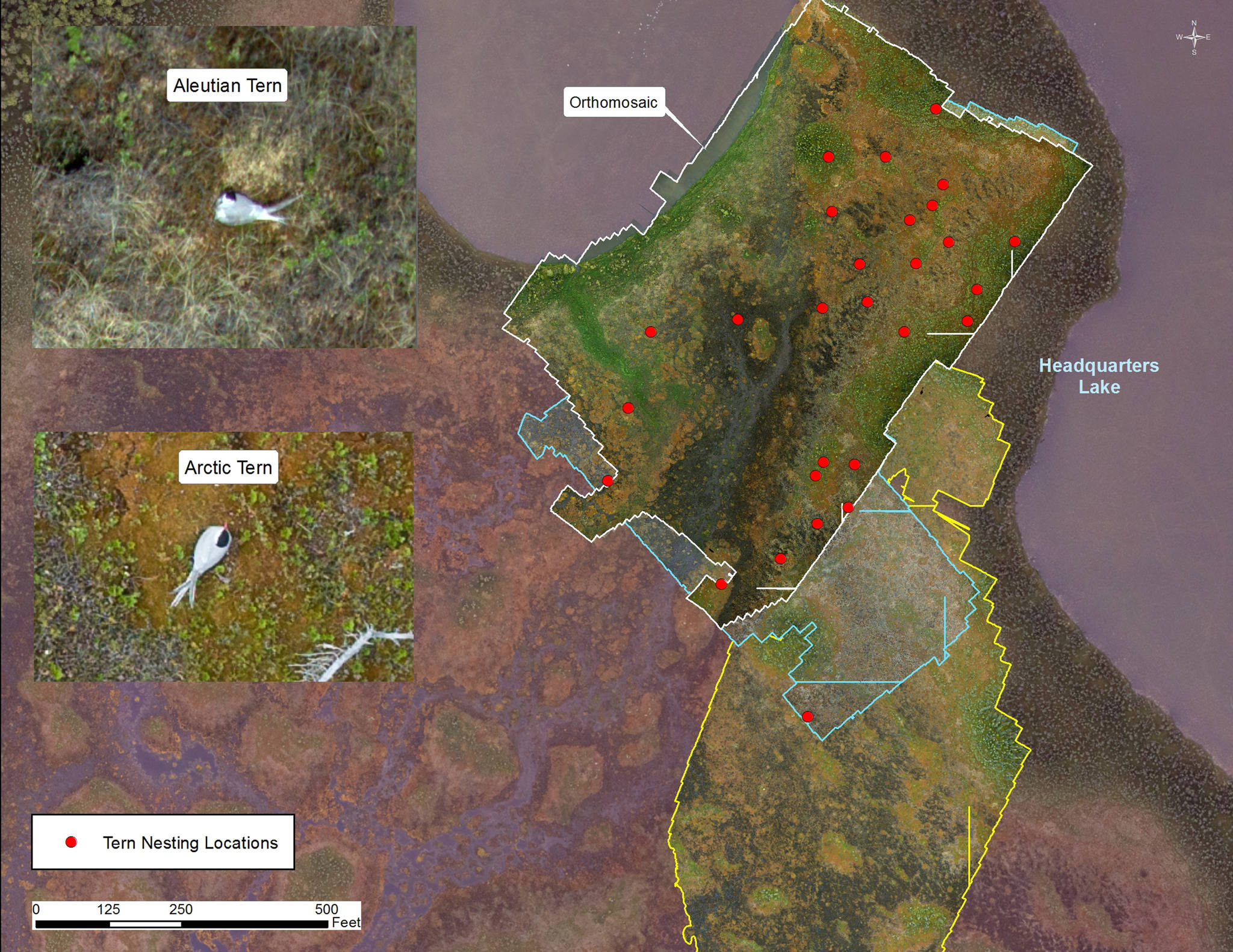
A small breeding colony of Arctic and Aleutian Terns nests by Headquarters Lake, a convenient 15-minute walk from the Kenai Refuge office. For several years, the colony has failed to produce any young. Little is known about Aleutian Terns, which have declined dramatically in recent decades.
Early in the field season, we did a pilot project to explore using a drone, or Unmanned Aerial System (UAS), to count nesting Aleutian Terns. Using the UAS, we hoped to find a more efficient way to survey without adversely impacting them in the process.
Two questions we wanted to answer. The first was whether flying our small quadcopter over the colony would disturb nesting terns. The high sensitivity of nesting Aleutian Terns to human disturbance was a major motivation for using UAS to remotely survey the colony. Any sign of negative disturbance, such as birds flushing from the nest and leaving or attacking the UAS, would obviously discourage their use. Secondly, we wondered if Aleutian Terns could be distinguished from Arctic Terns in the processed imagery. These two species look very similar, but Aleutian bills are black and those of the Arctic are bright red.
After test runs in May, we flew the first survey 100 feet above ground level (AGL) on June 7. The terns had been there for several weeks and probably started incubating the week before. We wanted all potential pairs to be incubating before the first flight, as it would be difficult to observe disturbance effects on terns prior to nesting.
During the first flight, terns ignored the UAS, and the terns showed clearly on processed images. Though we couldn’t distinguish species, we were comfortable letting the UAS get a closer look at 75 feet AGL. Again the terns ignored the UAS and you could see terns much better in the imagery.
I was ready to call it a success, but the true birders on the project, Dawn Magness and Todd Eskelin, were not convinced. Though the images were teasingly good, my colleagues were not ready to make a definitive identification. I understood — if you want to be a respected birder, it’s best to set a high bar.
Our colony nests in a complex of wetland, grass and shrub habitats. Getting close enough on foot to a nesting tern to pinpoint their cryptic nest and well-camouflaged eggs is very difficult. However, from above, nesting adult terns are conspicuous, especially if you happen to be an eagle. When threatened by avian predators, the terns flush from the nest and give chase, noisily driving the intruder away with relentless dive bombing.
More than halfway through the 21-day incubation period, based on behavioral observations from the blind, the nesting terns were not reacting to the UAS. Additionally, the terns were allowing gulls to fly within 15 feet of the nest without flushing. We did have a couple terns dive at the UAS during one of the higher flights, but this was right after attacking a bald eagle in the vicinity and the terns were agitated. Bald eagles are known to cause breeding failures for entire tern colonies.
With time running short we decided to make our next flights at 60 and 50 feet AGL. During a typical survey the UAS camera will take over 750 images. The images are geotagged, which means the latitude, longitude and elevation of the camera are associated with the image. The UAS flies back and forth over the survey area in a programmed flight plan so the photographs overlap each other on the sides by over 50 percent. The camera rapidly takes photos so each image overlaps the preceding one by 80 percent. The image processing software takes hundreds of overlapping images and uses the geotags and object recognition to align the photos and make a single image mosaic of the survey.
Using new technologies and approaches to help address management issues can be both exciting and aggravating. The lower altitude flights dramatically improved the images and my colleagues were confident they could definitely distinguish the two species based on bill color. The problem was the terns weren’t always looking in the right direction!
Don’t panic, it’s not over yet. When creating the mosaic, the imaging software selects just a portion from one image out of many overlapping images to make the mosaic. So using different camera angles from unselected images of the terns, our birders were able to positively identify the species of all but a few terns from the low altitude flights.
We wrapped up our UAS surveys on June 23. Twenty-eight potential nests sites were identified from eight surveys. Tern locations identified on the orthomosaic images were given a digital marker. Terns may leave the nest to forage or they may flush due to a predator. Having multiple surveys allowed us to produce a more complete survey.
In some instances when the adult was off the nest, we were able to find the nest using the digital marker and see individual eggs and chicks. Tern chicks frequently walk off the nest into thicker cover within a few days of hatching, so these were fortunate sightings. Because the young quickly leave the nest and hide, we don’t know how many fledglings survived. Next year we plan to use a thermal camera to find fledglings hiding in the grass.
All in all, the pilot testing of using UAS to survey nesting Aleutian Terns went well. We are confident these technologies will help in conservation efforts for these globetrotting birds.
Mark Laker in an ecologist at Kenai National Wildlife Refuge. Find more information about the Refuge at http://www.fws.gov/refuge/kenai/ or http://www.facebook.com/kenainationalwildliferefuge.

