Scientists warn of potential landslide, tsunami in Prince William Sound area
Published 10:30 pm Wednesday, May 13, 2020
State geologists are warning the public about an unstable mountain slope in Prince William Sound that has the potential to fail and generate a large tsunami in the area, according to a Thursday press release from the Alaska Department of Fish & Game.
A landslide-generated tsunami in the area is possible within the next year and “likely” to occur within 20 years, according to scientists.
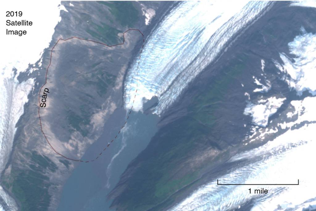
Steve Masterman, director of the Division of Geological and Geophysical Surveys, said that he and his staff have received indications that the Barry Glacier, located 20 miles northeast of Whittier, is retreating rapidly from the Barry Arm, and its movement could release millions of tons of rock into the nearby Harriman Fjord.
This, Masterman said in the release, would cause a tsunami “at least as large as some of the largest in the state’s recorded history.”
“The most noteworthy of these tsunamis was in 1958, when a landslide entered the Lituya Bay Fjord in Glacier Bay and generated a wave that went 1700 feet up the opposite side of the fjord,” Masterman said. “The most recent was at Southeast Alaska’s Taan Glacier in 2015, where a wave went 600 feet up the opposite wall of the glacial valley.”
The potential slide in Barry Arm is predicted to be much more intense than the two historic landslides referenced in the release. Masterman and his team estimate that the rock masses released in those slides were about one-tenth the size of a potential slide in Barry Arm, based on studies of the pre-slide topography, the geometry of the outfall, the presence of scarring and other data that was compared to the Barry Arm region.
Based on preliminary models, scientists have estimated that, in the event that most of the landslide mass fails at once, a tsunami hundreds of feet in elevation would hit the shoreline in Barry Arm and Harriman Fjord. Whittier would see a tsunami over 30 feet above the tide within about 20 minutes, while Valdez, Tatitlek and Cordova could also see waves large enough to produce dangerous currents in the docks and harbors.
Scientists are hoping to conduct landslide studies of the Barry Arm in order to better predict the effect that a tsunami would have on the area, but felt that the preliminary models were sufficiently detailed to support the issuance of this warning.
The Barry Arm is part of an “accretionary prism,” an area where plate tectonics forced sedimentary rocks to merge with Alaska’s southern shore long ago in geological history. This process formed faults and cracks in the landscape which were further eroded by the formation and movement of glaciers.
As glaciers retreat from the area, the walls of the glacial valley start to fall apart from the lack of support, which leads to rockfalls and landslides that can cause tsunamis when they hit the ocean.
Masterman said in the release that predicting a landslide with any amount of precision is impossible, but there are certain indicators that often lead to a landslide event: significant rainfall or snowfall, seismic activity and continuing glacial retreat all make landslides more likely.
“As global warming continues to thaw glaciers and permafrost, landslide-created tsunamis are emerging as a greater threat,” Dr. Anna Liljedahl with the Woods Hole Research Center in Massachusetts said in the release. “Not just in Alaska, but in places like British Columbia and Norway.”
Because the area attracts many boaters and campers in the summer, the Alaska Department of Fish and Game and the Department of Natural Resources are recommending people avoid the area until the hazards are better understood.
The Division of Geological and Geophysical Surveys will be working with agencies including the USDA Forest Service, the U.S. Geological Survey and the Woods Hole Research Center to monitor the situation and collect data on the region’s bathymetry and geometry in order more accurately predict the size of a potential tsunami and how it would affect the area.
Scientists involved in this effort have sent an open letter to stakeholders explaining the situation and asking local communities for their input in the ongoing research.