Refuge begins planning for Ski Hill Road trail
Published 4:25 am Friday, October 13, 2017


The wheels are finally starting to turn on a plan to get a trail built to get foot traffic off Ski Hill Road.
The road, which winds up into the woods just south of Soldotna and connects Funny River Road to the Sterling Highway, is a popular spot for people to run and walk year-round. It’s also the main access for the Kenai National Wildlife Refuge Visitor Center and headquarters, so cars also frequent the road on their way up to the visitor center and trails behind it. In the past, the dual uses have led to some conflicts between users, especially in the deep darkness of winter along an unlit road.
So a few years ago, the Kenai National Wildlife Refuge administrators began looking at ways to build a trail away from the main road to reduce some of those conflicts. The plans are finally coming together, with design help from the Federal Highway Administration’s Western Federal Lands division.
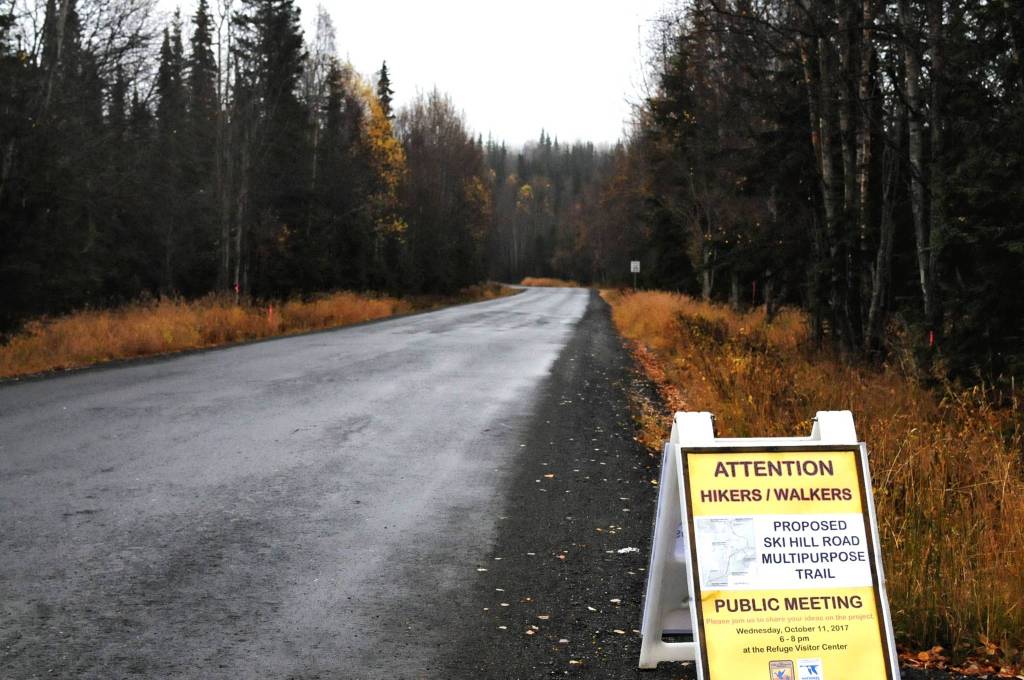
Members of the public got a first look at some of the draft concepts for a trail at a meeting Wednesday night at the refuge visitor center. The concepts are still very loose, though, said project manager Reuben Johnson, who works for Western Federal Lands out of Vancouver, Washington.
“We’re essentially a blank slate, which is kind of cool,” he said. “We are seriously looking for your input.”
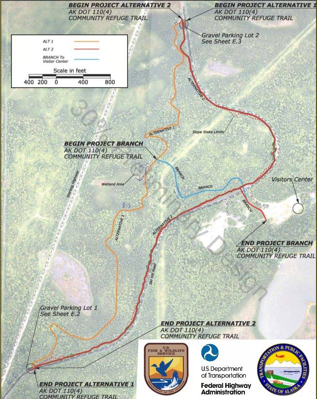
The designers came up with three basic alternatives, but are looking for modifying suggestions. Refuge Manager Andy Loranger said the trail would be multipurpose, meaning bikes, dogs, skis, hiking and running would be allowed, unlike on the current refuge trails, where no dogs or bikes are allowed.
“The intention is to continue the current uses of Ski Hill Road,” Loranger said.
The funding comes from an approximately $2 million grant, Johnson said. The funds probably aren’t enough to construct multiple alternatives up to the standards the refuge would prefer, but a combination of different alternatives or standards could be possible.
The basic parameters are for an unpaved trail, approximately 1.7 miles long, on the north side of Ski Hill Road. One of the alternatives winds more through the undeveloped wooded area between Ski Hill Road and the Sterling Highway, and another follows the road, like an offset sidewalk trail. Johnson said the project managers are working with the refuge staff to survey for eagles and other birds as well as to gather information about the geography of the area where the trail would be, which is partially hilly forest and partially wetland.
The area the trail would run through is geographically very similar to another trail system directly across the Sterling Highway — the Tsalteshi Trails, which curl through the woods just north of Skyview Middle School. It’s long been part of the conversation to ask whether a future trail development along Ski Hill Road could connect the refuge trails to Tsalteshi through some kind of underpass beneath the Sterling Highway, creating a continual recreational trail system south of Soldotna.
Loranger said the refuge encourages people to use walking or biking to get to the visitor’s center and headquarters as alternatives to driving. While it may not be practical to connect all the trails now or to connect the Ski Hill Road trail to the Unity Trail that links Kenai to Soldotna, the community clearly supports a networked trail system, he said.
“We at the refuge think it’s a very viable and great idea and we’d love to see (the connectivity),” Loranger said.
Johnson said it wasn’t in the cards for that connector to be part of this project, but they were aware of the interest in it. He said the project would be designed not to block off access for a culvert or some other kind of connector in the future, though it wouldn’t be explicitly planned for.
Attendees at the meeting gave mixed feedback about the potential designs for a trail. Some favored a trail that paralleled the road because if the intent was to get pedestrians off the road, it would make sense to just separate them from traffic. Others said they hoped to create a trail more like the existing refuge trails, back in the woods, or hoped for a loop trail.
“I see a trail in a lot of ways as a thing of beauty in itself,” said Bill Holt, who maintains the trails in the Tsalteshi Trails system. “In that sense, my preferred sense of the trail is not something that is utility where you can get from Point A to Point Be, but something that is following the contours of the land, that is a joy to walk on, bike on, ski on, whatever you’re going to use it for.”
Holt pointed out that there are dog mushing trails down Funny River Road as well, which this trail could connect to, and the students at Skyview Middle School have close access to it as well. He said he preferred the idea of a loop trail so it wouldn’t have to be as wide because there wouldn’t be as much two-way traffic. Several other attendees said they would prefer to see a well-lit trail, close to the road, that people could use for dog-walking or fitness walking.
Once the trail is built, it will be conferred to the refuge for maintenance, Johnson said. He encouraged everyone at the meeting to submit comments in writing and said “we’re not married” to any of the ideas they have for the trail at present.
He said the design team will review the comments and try to come up with a middle ground between people’s preferences for the trail’s look and usage.
“That’s what makes a project like this kind of difficult, trying to thread the needle between (users’ preferences),” he said.
Western Federal Lands will work with the refuge on particulars of the trail and is hoping to take comments, both by mail and electronically, for about the next month, he said. Comments can be mailed to Johnson at Western Federal Lands Highway Division, 610 East Fifth Street, Vancouver, WA, 98611 or emailed to Reuben.Johnson@dot.gov.
Reach Elizabeth Earl at elizabeth.earl@cmg-northwest2.go-vip.net/peninsulaclarion.