DOT unveils options for Cooper Landing Bypass
Published 5:24 am Thursday, April 2, 2015
The Alaska Department of Transportation and Public Facilities wants feedback on plans to move the Sterling Highway around Cooper Landing.
DOT released a draft supplemental environmental impact statement March 29 with four alternatives to improve traffic flow and increase road capacity on a 13-mile stretch of the Sterling Highway.
Cost estimates for the road construction options range from $250 million to $304 million.
Cooper Landing is a Southcentral recreation mecca for Alaskans and tourists alike each summer. Significant amounts of additional traffic traveling between Anchorage and the southern portion of the Kenai Peninsula pass through the community as well.
The project area encompasses the entire portion of the Sterling Highway in the Upper Kenai River valley — where it begins to follow the Kenai Lake shoreline near milepost 44 to its eastern intersection with Skilak Lake Road at milepost 58.
That section of the highway contains numerous campground and trailhead turnoffs, driveways and side roads. It also includes the extremely popular salmon and trout fishing area at the mouth of the Russian River.
The engineering services and consulting firm HDR Inc. prepared the environmental impact statement, or EIS, for the state.
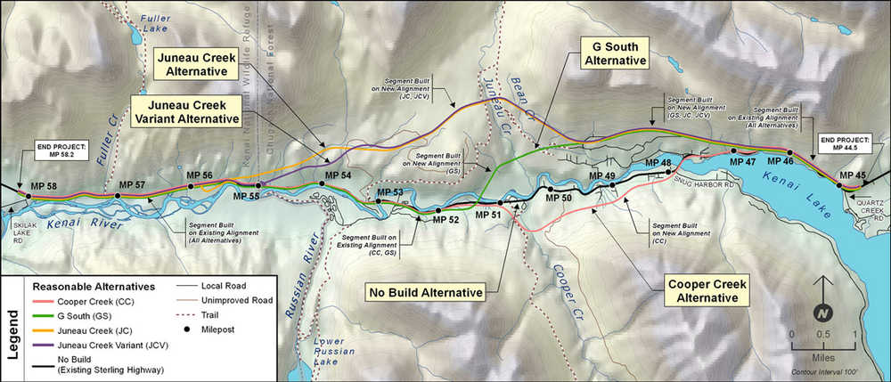
Three of the alternatives deviate from the current highway near milepost 46, a couple miles east of the Kenai Lake bridge. The “G South,” “Juneau Creek” and “Juneau Creek Variant” options would move the highway north of Cooper Landing and the Kenai River.
The G South option would require a new bridge over the Kenai between miles 51 and 52. It would follow the current right-of-way through the rest of the corridor. The Juneau Creek plans keep the highway completely on the north side of the river through the project area and reconnect with the current road between miles 55 and 56.
The “Cooper Creek” alternative is the only proposal that expands the highway to the south and uses the Kenai Lake bridge. It would relocate the Sterling farther south than its current path from mile 48 to mile 51 and from there it would follow the current right-of-way.
A record of decision would likely come next year and construction would run for five years beginning 2018, based on the current project timeline.
Cost breakdown
■ Cooper Creek: $236.2 million for construction and $54.5 million in associated expenses for a total project cost of about $291 million.
■ G South: $250.4 million for construction and $53.1 million in associated expenses for a total project cost of $304 million (includes a new Kenai River bridge).
■ Juneau Creek: $205.4 million for construction and $44.2 million in associated expenses for a total project cost of $250 million.
■ Juneau Creek Variant: $211.6 million for construction and $45.4 in associated expenses for a total project cost of $257 million.
(Associated expenses include permitting, design, utility relocations and right-of-way acquisition through private property.)
Federal highway program funds would pay for the majority of the project, which would require a state match.
The revamped stretch of highway would have 12-foot lanes, eight-foot shoulder sections, passing lanes and left-turn lanes — features the stretch of highway currently lacks.
The Sterling Highway through Cooper Landing does not adequately meet DOT safety standards for a main thoroughfare as it is constructed. It is one of the only segments of the Sterling still in its original right-of-way from construction in 1950.
Despite a winding, narrow roadway squeezed between mountains and river in several stretches, the Cooper Landing Bypass area has a crash rate 4.6 percent lower than the state average for similarly classified rural primary highways. From 2000 through 2009, the Sterling Highway has a crash rate of 1.72 crashes for every 1 million vehicle miles traveled per highway mile, while the state average was 1.80 crashes for the period.
The winter crash rate was nearly four times higher than the summer even though average winter daily traffic through the corridor was 1,635 vehicles, compared with an average of 4,353 vehicles in summer.
DOT spokeswoman Shannon McCarthy said crash rates increase on either side of the project area as drivers “jockey for position” on highway stretches with speed limits of 55 miles per hour. Much of the subject corridor is posted at 35 and 45 miles per hour and traffic often backs up as vehicles wait to turn off the highway.
Signs put up by residents along the roadway through Cooper Landing encourage travelers to follow posted speeds and hold the slogan “We Drive 35.”
Summer traffic volumes are expected to increase more than 80 percent from current levels over the next 30 years based on historical 20-year trends, according to the EIS.
DOT has looked at upgrading the highway numerous times since the 1980s. The current EIS is a revision of a project proposed in 1994 that looked at revamping the Sterling Highway milepost 37-60. The eight-mile segment beginning at milepost 37 was ultimately redone and completed in 2001.
DOT is accepting public comments on the EIS through May 26. Comments can be submitted through the project’s website, www.sterlinghighway.net, or at libraries in Anchorage, Kenai, Soldotna, Cooper Landing and Juneau.
Elwood Brehmer can be reached at elwood.brehmer@alaskajournal.com.