
Stakeholders and Native tribes are being asked to weigh in on updates to Alaska’s plan for dealing with oil spills, especially identifying locations where the use of oil dispersants should be avoided.
Representatives from state and federal agencies came to Kenai on Thursday to gather input on and learn about the Alaska Federal/State Preparedness Plan for Response to Oil and Hazardous Substance Discharges/Releases, otherwise know as the Unified Plan. The Unified Plan’s guidelines on the use of oil dispersant were updated in January.
Dispersants, which are a mixture of solvents, surfactants and addivites, break up oil slick into smaller droplets and promote oil biodegration into the water. They are used to reduce oil exposure to those working to clean up an oil spill and reduce the threat to wildlife near or on the shoreline when they are applied to the spill further out in the water, said Catherine Berg, a presenter from the National Oceanic and Atmospheric Association.
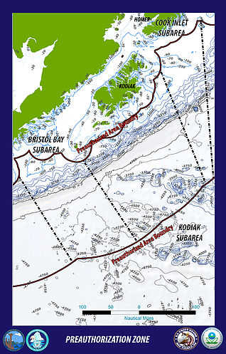
Thursday’s meeting focused on the Alaska preauthorization zone for dispersants, which includes Cook Inlet. Preauthorization areas allow the federal on-scene coordinators handling oil spills to make a decision about using dispersants with pre-approval from agencies like the Environmental Protection Agency, Department of Environmental Conservation and the State of Alaska, said Lt. Commander Matt Hobbie with the U.S. Coast Guard during a presentation Thursday.
“The plan preauthorizes the federal on scene coordinator to make an independent decision to move dispersants, but it doesn’t mean that dispersants are required to be used in the preauthorization area,” Hobbie said.
In undesignated areas, the coordinator would have to go about getting that approval from all the necessary agencies before making a call during any given spill.
“For areas that are not in the preauthorization plan, the on-scene coordinator may authorize use of dispersants only with concurrence from the EPA and … DEC after consultation with natural resource trustees,” Hobbie said.
The preauthorization area discussed at Thursday’s meeting includes not only the Cook Inlet subarea, but also the subareas of Prince William Sound, Kodiak, Bristol Bay and the Aleutian Islands. It begins 24 nautical miles offshore and stretches to 200 nautical miles south. The area extends to the maritime boundary line just west of the Aleutian Islands, and then reaches out to 100 nautical miles north of the islands.
Additional public meetings will be held in Prince William Sound, Kodiak and Dutch Harbor to gather public input on those subareas. Though no one at Thursday’s meeting submitted formal public comments, comments will be accepted until Jan. 9, 2017. Those working on the plan were given 24 months to identify avoidance areas within the larger preauthorization area.
Avoidance areas are used to guide on scene coordinators when they make decisions about whether or not to use dispersants in a given location during an oil spill.
“An avoidance area does not exclude an area necessarily from the potential use of dispersants,” Hobbie clarified. “It means that the case-by-case authorization process will be used in that area.”
If the Cook Inlet subarea became an avoidance area, for example, the on-scene coordinator would not be pre-approved to apply dispersants there, and would have to go about getting authorization from the appropriate agencies as would happen in an undesignated area.
Hobbie stressed that every oil spill is different and that a number of factors go into deciding whether to use dispersants and where, such as whether they can be effectively applied to the oil in the given circumstances, and the potential threats to fisheries, endangered species or the environment.
Cleaning up oil spills mechanically will always be the first choice, said Commander Stacey Mersel, deputy commander of the Anchorage sector of the U.S. Coast Guard and the alternate federal on-scene coordinator for Alaska. Hammering out the preauthorization areas and potential avoidance areas in the Unified Plan will allow coordinators to make more informed decisions in the event that dispersants come into play.
“In any response, we want to use the most effective tool, the appropriate tool in any given situation and that’s really what this is all about,” she said.
Hobbie also included in his presentation that preauthorization areas only apply to crude oil spills. There are also restrictions against applying dispersants to the water at night, so as to have the best chance of being able to see and avoid large groups of wildlife.
Dispersants also cannot be used within 500 meters of what presenters called “swarming fish,” marine mammals in the water or near haul-outs.
Stakeholders and tribes wishing to submit public comments can do so at the project’s website, nukadraft.wixsite.com/avoidanceareas.
Reach Megan Pacer at megan.pacer@peninsulaclarion.com.
