
In thinking about highlights in 2016 for the Kenai National Wildlife Refuge, I’m reminded yet again that what is valued is ultimately in the eyes of the beholder.
If you’re a hunter, you’d be happy to hear there were 23 fires this past year. Most were flare-ups from the 2015 Card Street Fire, but some were from the 2014 Funny River Fire.
Most moose hunters know that when wildfire burns down to mineral soil, spruce forest converts to birch and aspen, two hardwood species that help sustain moose during the winter. Biologists from the Refuge and the Alaska Department of Fish & Game shared GPS data from collared moose cows in Game Management Unit 15B this past year to not only understand how moose are responding to the Funny River Fire, but also to understand how moose use the urbanizing landscape on the western Kenai Peninsula.
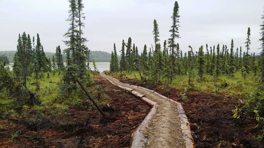
If you’re someone who likes to hike, you’ll be glad to hear of a new trail in the Refuge’s Skilak Wildlife Recreation Area. The Marsh Lake trail winds its way along a whimsically implemented dozer line that helped stop the Card Street Fire.
Though the line may not be direct, its destination is a direct result of strategic firefighting. Marsh Lake made an ideal anchor for fire suppression operations due to the network of wetlands surrounding its cool banks.
The Refuge trail crew, a Student Conservation Association high school crew, and fire management personnel came together and pulled off the most complex trail project to date on the Refuge. More than 600 linear feet of heavy timber was cut from the Three Johns Road thinning project and brought to the end of the 3-mile trail. After logs were debarked and spiked into place, 100,000 pounds of rock and dirt had to be hauled in freighter frame packs to the lake.
What resulted was a turnpike that keeps you out of the wetland goo for more than 300 feet!
On the other hand, if you’re a homeowner in the central peninsula, you’ll be relieved to know that Refuge fire staff worked with Alaska State Division of Forestry, Cook Inlet Region, Inc., Chugachmiut, Kenai Peninsula Borough, and ADF&G to create defensible space around Sterling.
The partnership completed nine fuels treatments on more than 220 acres either mechanically or through prescribed fire as part of the Sterling Community Wildfire Protection Plan. Strategic fuel reduction around communities adjacent to refuge lands gives the Refuge Manager a little more wiggle room to allow lightning-caused wildfires to run, a desired outcome if communities are not put at risk.
And because the Refuge landscape has changed so much in recent years due to the effects of wildfire, spruce bark beetle outbreaks, and a rapidly warming climate, you’ll be glad to know that biologists and remote sensing specialists from the Forest Service, Kenai Fjords National Park, Kenai Peninsula Borough, and others have partnered this past year to begin remapping the landcover of the Kenai Peninsula (last done a decade ago).
A new tool being used in combination with satellite imagery and on-the-ground vegetation data is high resolution aerial photography, brought into focus with better digital cameras and Structure from Motion, a computer-intensive software capable of producing orthophotographs and 3-D spatial surface data.
Managing the Kenai Refuge, as with many public lands, requires multiple hands to help address the various demands for its natural resources and access to open space. It’s easy to forget that the refuge is not “just” 2 million acres of wildlands.
As one of only two refuges on the Alaska Highway system, Kenai Refuge also serves local residents, half of Alaskans who live in the Anchorage area, and the many tourists who drive the ALCAN or choose to rent cars or RVs while here in Alaska.
An artifact of these sometimes competing demands is that the Refuge has a large human footprint. Consider that Kenai Refuge encompasses more than 100 miles of maintained road, 110 miles of maintained trails, 150 miles of utility and transmission lines, 14,000 acres of lands leased for commercial oil and gas extraction, 16 public use cabins, 15 established campgrounds, two canoe systems, a new visitor center, and the various facilities that provide space to educate local youth as well as office space for administrative staff.
In 2016, Kenai Refuge supported over 60 permanent and seasonal staff, interns, volunteers and students to help ensure your public lands and facilities were managed in such a way to be safe and welcoming, but as minimally intrusive as possible to the surrounding natural landscape.
As a final highlight for 2016, the Kenai Refuge celebrated 75 years of conservation on Friday, December 16th. Sponsored by the Friends of Alaska National Wildlife Refuges, National Wildlife Refuge Association, Alaska Geographic and U.S. Fish and Wildlife Retirees Association, more than 200 guests attended this evening event that showcased the Refuge’s diverse landscapes through artwork by volunteer photographers Tom Collopy and Mary Frische, family activities and a centerpiece cake that, well, took the cake.
And, at the end of the day, it’s good to see the refuge through the eyes of artists.
From the entire Kenai Refuge staff, best wishes to all of you for a peaceful and joyful holiday season!
Dr. John Morton is the supervisory biologist at Kenai National Wildlife Refuge. Find more information about the refuge at http://www.fws.gov/refuge/kenai/ or http://www.facebook.com/kenainationalwildliferefuge.
