Since I was a little boy, I’ve been interested in exploring the underwater world. My favorite TV show was the Undersea World of Jacques Cousteau. Though our lakes don’t offer quite the array of colors and charismatic species as a coral reef, they can be rich and interesting environments to explore. Just like on land, the richness of aquatic species is associated with habit availability and quality.
For me, the ideal method to explore the underwater world is putting on my mask, fins, and snorkel or SCUBA gear and jumping in the water. On a small scale this works, but for large area, we need other methods. Our current project exploring aquatic habitat involves the elodea infestation in Stormy, Daniels, and Beck Lakes. Elodea is a nasty aquatic invasive plant that has the potential to displace native plant species and choke off waterways.
We have conducted numerous “rake surveys” to determine the presence of elodea on the Kenai Peninsula. This involved tethering a garden rake head to a rope and dragging it across the lake bottom to sample plants. From these surveys, we learned elodea prefers shallow soft bottom areas. Therefore, we wanted to map depth, bottom hardness, and presence of vegetation across entire lakes to understand where the best elodea habitat exists.
The first step in creating our lake habitat map to collect depth data for a bathymetric map. A bathymetric map is the underwater equivalent of a topographic map with contours for depth instead of elevation. All that is needed is location and depth, and lots of it. Not long ago it was an expensive and complicated task to record GPS location and depth, and then process it into depth contours.
Researchers are constantly looking to the consumer market for readily available equipment and solutions. These are called “off-the-shelf” solutions, and can save time and money. For this project, we used the Lowrance HDS Charter/Sonar with StructureScan to measure depths and locations. The recorded data was then processed by Contour Innovations (http://www.contourinnovations.com/). This off-the-shelf solution was recommended to me by ADFG biologist Robert Massengill who was working on another eradication project for invasive northern pike in Stormy Lake.
The Lowrance HDS sonar works by emitting an ultrasonic pulse directly below the boat and receiving the echo as it bounces of the lakes bottom or vegetation. This is also referred to as a down-scanning sonar. The StructureScan operates at a higher frequency which is better for distinguishing vegetation and underwater structures. In addition to down-scanning, the StructureScan utilizes side-scanning technology. As opposed to the down-scan sonar which generates a profile or side view of the bottom, the side-scan sonar looks off to the sides to create an actual image of the bottom.
To collect the data we ran transects (spaced 100 feet apart) back and forth across the lake at a speed of about 6 mph. Typically when boating you try to avoid obstacles, but when mapping you almost intentionally run over them. On Daniels Lake we encountered some glacial erratics that were about 20 feet across – those are some big rocks! Needless to say, Daniels Lake made a few modifications to our prop.
Contour Innovations offers two services: LakeTrax for anglers, and ciBioBase for research. Before acquiring the research version, I experimented with the LakeTrax service by mapping the outlet of Tustumena Lake down to the boat launch. Anyone who has navigated that stretch of water knows there are some nice boulders covered with aluminum strips just upstream of the launch. With just a few hours of mapping, I was able to create a nice bathymetric map and identify hazards. You can save maps back on your Lowrance HDS unit, and in the future avoid leaving any trace of your boat on the rocks.
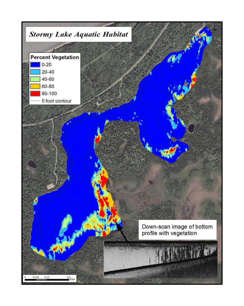
Beyond lake depth and obstacles, we also needed information about vegetation and the bottom substrate to understand elodea habitat. Therefore, our lake data (called sonar logs) were processed by the research service, ciBioBase, to produce three layers: depth, bottom hardness, and percent vegetation biomass. Bottom hardness is calculated by how well the sound signal is reflected off the lake bottom. Harder surfaces reflect well and soft surfaces tend to absorb sound. Percent vegetation biomass is simply the percent of the water column that is occupied by vegetation (plant height divided by water depth).
From the new data layers we will produce a map identifying areas of the lake with suitable habitat for elodea. These will be important for both treatment and monitoring efforts. Though I’ll still need to put on my mask and fins to see for myself what’s really under the water.
Mark Laker has been an Ecologist with the Kenai National Wildlife Refuge since 2003.