
When you think of data-driven careers, the natural resource field is probably not the first profession that comes to mind. I envision a guy or gal sitting behind a super computer in the Silicon Valley running algorithms and crunching data.
But data and analytics have found their niche in almost every profession in the world. As a sports fan, I notice that sports broadcasters commonly have a guest analytics expert to narrate decisions made by head coaches and managers.
Fire management officials use data and analytics as aids in the decision-making process as well. Some firefighters eventually become fire managers, trading in their fire boots and pulaskis for a computer. We multitask computer applications to manage information during a wildland fire.
Fire managers deal with a litany of risk-based analysis challenges, as we make decisions in a time compressed environment. To alleviate that stress load, pre-fire season planning is essential in any fire manager’s toolbox. Much of that preseason planning takes place between now and next spring. I often hear the question, “What do you do in the winter?” Well, the simple answer to that question is, “we plan.” And we use data to do that.
A relatively new tool in the fire management world is the Unmanned Aerial System (UAS) or drone. Drones collect data and make it available in almost real time.
Drones give fire managers and operations personnel access to information that has rarely been available in the past. Outfitted with an infrared camera, a drone can fly in heavy smoke while detecting hot spots, spot fires and other heat sources that threaten containment lines. Until drones came along, we really didn’t have the capability or access to this kind of information, especially in such a short turnaround time. Conventional aviation assets (either fixed- or rotor-winged aircraft) are extremely limited in capability during events with heavy smoke. Drones have made the impossible possible by providing near real-time data to those who make decisions on the fire line.
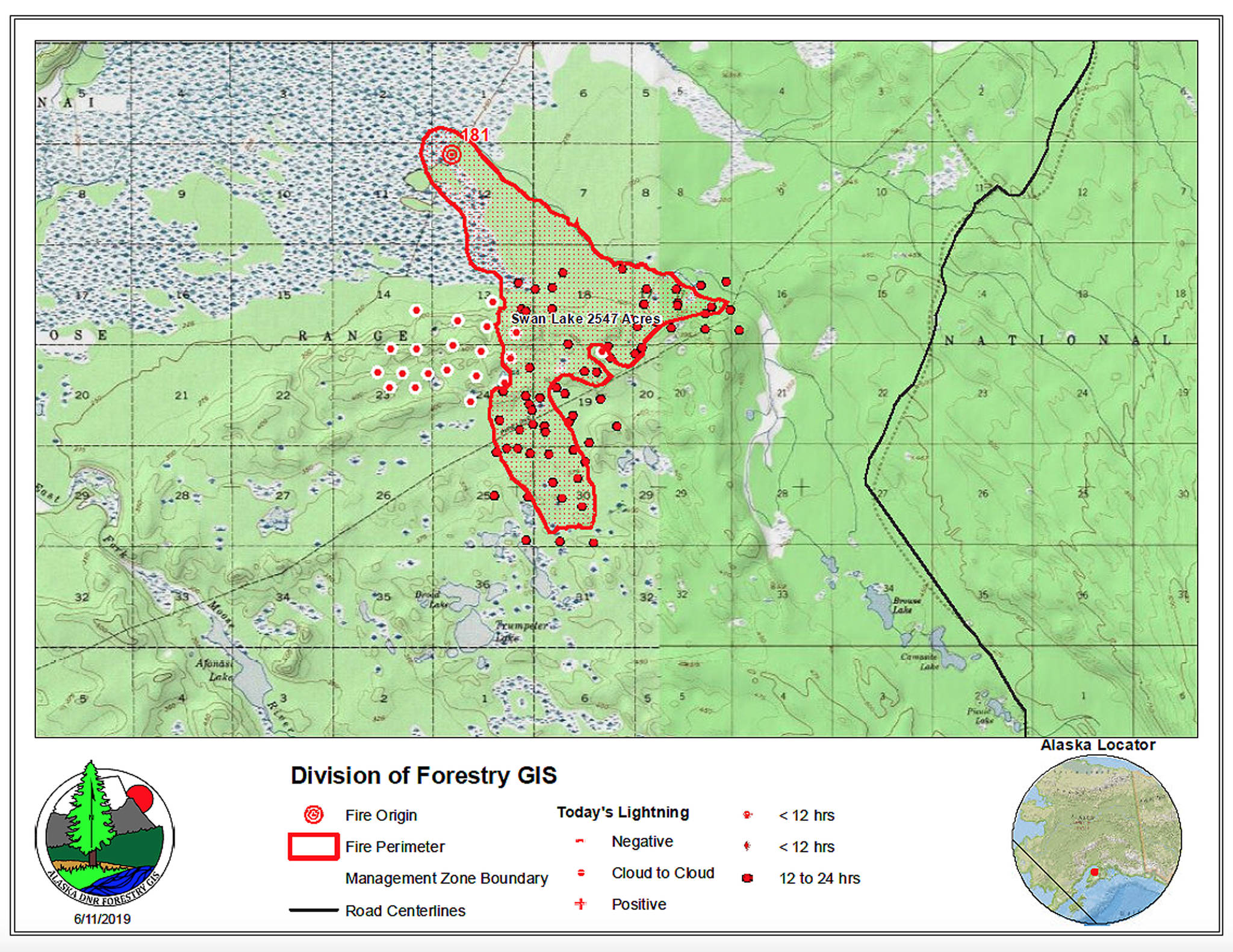
Satellite imagery is one of the core data sets that fire managers use in making decisions. From imagery that is available daily (yes, daily!) to heat signatures, to finding structures from images, to snow cover (or lack of snow cover), satellites provide fire managers with critical data.
Especially in a state as vast as Alaska, the conventional ways of mapping a fire (walk or fly around the fire perimeter with a GPS) aren’t practical in many cases, so we use daily satellite images to map the fire perimeter. It actually is more accurate because there’s less human error.
Heat-sensing technology has advanced to a degree that fire managers can access heat signature data, derived from satellite data. An incredibly valuable data set, heat signatures also contribute to decision making. We essentially see where a fire is moving from our computers.
Of course, there are constraints with satellite data. Satellites pass directly overhead every four to six hours. That may seem like a long time, but compared to places in the Lower 48, that is quite frequent due to the smaller circumference of the earth at our northern latitudes.
Today we have more access to weather data than ever before. Our cell phones help make us experts in weather forecasting. In an age of instant gratification, weather observations taken hourly almost seem agonizingly slow.
However, in the wildland fire profession, the RAWS (Remote Automated Weather Station) does exactly that. It records data such as temperature, relative humidity, dew point, precipitation, wind speed and wind direction. From those hourly observations, calculations are automatically made and fire weather indices are calculated. In Alaska, those calculations include fine fuel moisture code, duff moisture code, drought code, initial spread index, buildup index and fire weather index. These data on an hourly basis are extremely valuable during the sometimes very short window between decisions.
What about the “old fashioned” way that firefighters collect weather data? It’s still common practice for fire crews to “sling” weather with a sling psychrometer and an anemometer — they collect the same basic data that a RAWS station collects. These on-the-ground observational data help calibrate, validate and inform weather forecasters. These data are also invaluable.
Data is here to stay. Our challenge in the world of wildfire management is to organize and make sense out of all the data available to us. Still, we need to balance screen time and field time. Even fire managers need some time on the fire-line to stay grounded in reality.
Michael Hill is the Assistant Fire Management Officer for Alaska Southern Refuges, stationed at Kenai National Wildlife Refuge. Find more Refuge Notebook articles (1999–present) at https://www.fws.gov/refuge/Kenai/community/refuge_notebook.html.
