A map of areas closed to snowmachine use in the Chugach National Forest. (Provided by U.S. Forest Service)

A map of areas closed to snowmachine use in the Chugach National Forest. (Provided by U.S. Forest Service)

Snowmachine use closed in parts of Chugach National Forest, opened in refuge

On the refuge, all areas “traditionally open to snowmachine use” are now open

Snowmachine use on the Kenai National Wildlife Refuge opened this week, a week after the Chugach National Forest closed some of its areas to snowmachine use citing “inadequate snow conditions.”

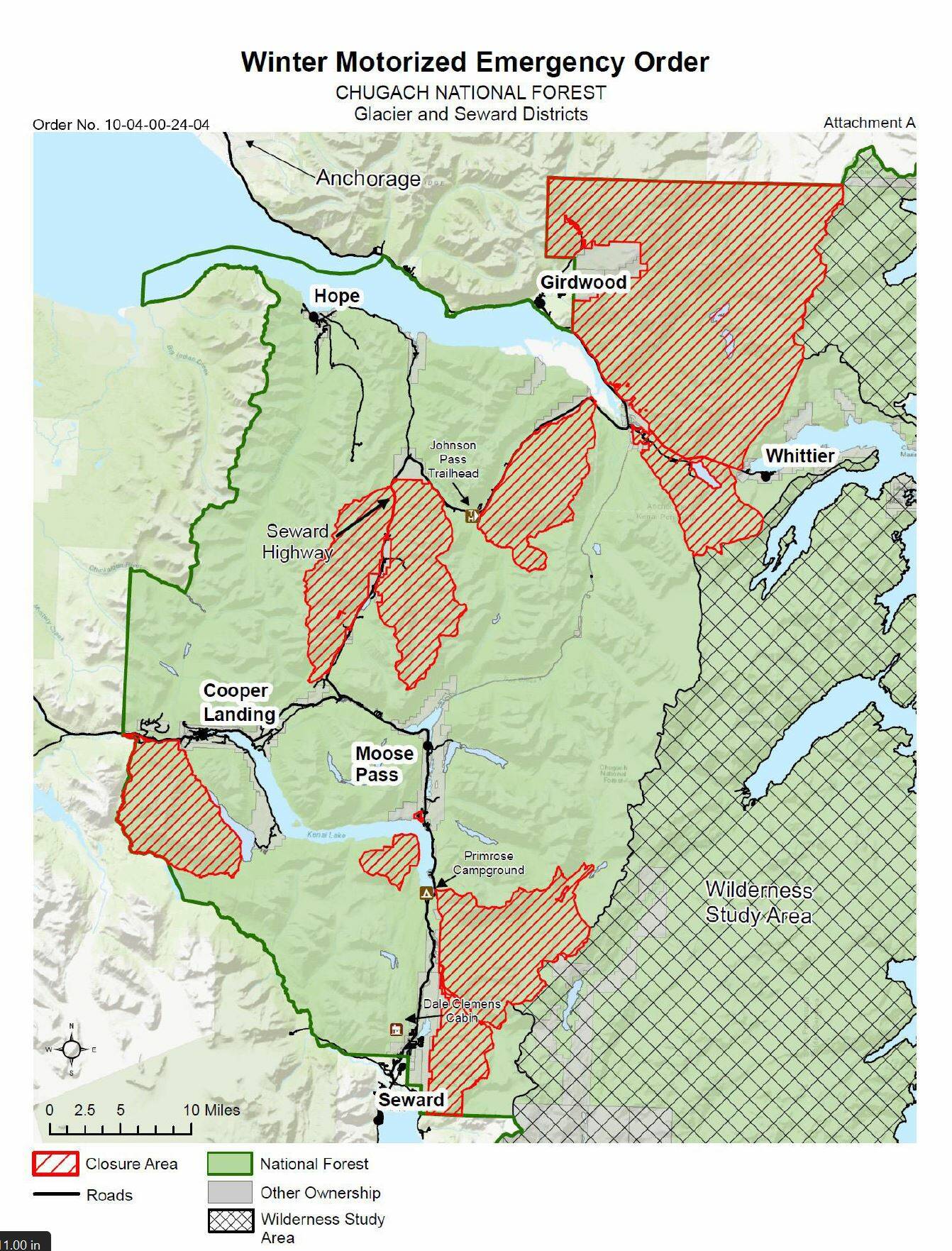
An emergency order published by the U.S. Forest Service on Wednesday, Dec. 13, says that parts of the Seward and Glacier Ranger Districts are closed to the use of snowmachines. An announcement from the service connected to the order says that without enough snow coverage on the forest floor, use of snowmachines can damage resources.

The closed areas include multiple areas along the Seward Highway, including near Johnson Pass Trailhead, as well as near Cooper Landing and Seward. The order says that Placer River and Lost Lake Trailhead have received enough snow and remain open.

ADVERTISEMENT
0 seconds of 0 secondsVolume 0%
Press shift question mark to access a list of keyboard shortcuts
00:00
00:00
00:00
 

The order, and the closure, will be in effect until Feb. 15, “unless rescinded sooner.”

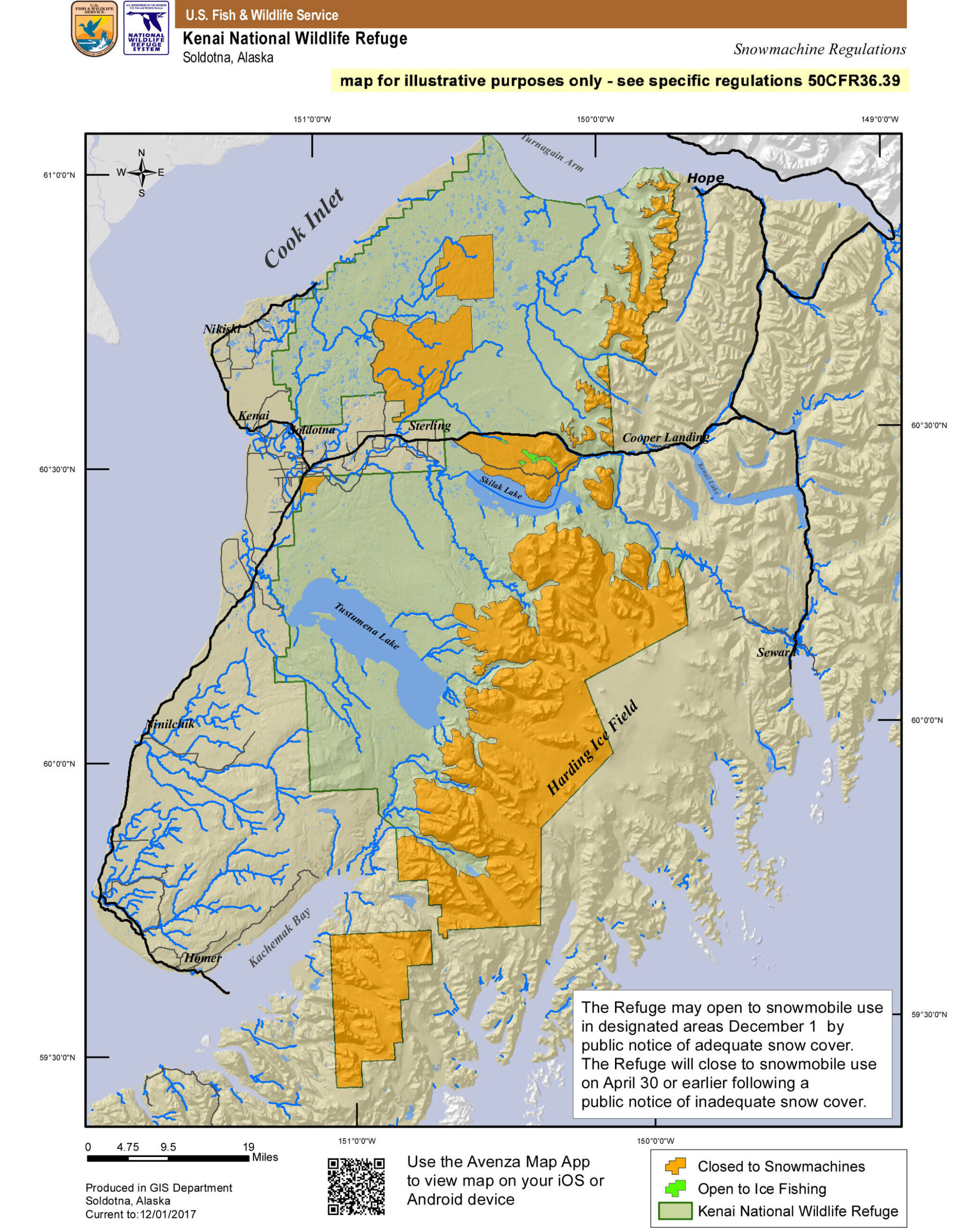
On the refuge, all areas “traditionally open to snowmachine use” are now open, according to a news release from the U.S. Fish and Wildlife Service. This does not include the Headquarters area, Skilak Wildlife Recreation Area, Swan Lake and Swanson River Canoe Systems, and those areas above the timberline — excepting the Caribou Hills.

A map of the closed area can be found at fs.usda.gov/chugach. Maps of the areas opened on the refuge and closed in the national forest will also be included with this story online at peninsulaclarion.com.

Reach reporter Jake Dye at jacob.dye@peninsulaclarion.com.

A map of areas now opened to snowmachine use in the Kenai National Wildlife Refuge. (Provided by the U.S. Fish and Wildlife Service)

More in News

Foliage surrounds the Soldotna Police Department sign on Tuesday, Aug. 30, 2022, in Soldotna, Alaska. (Ashlyn O’Hara/Peninsula Clarion)
Soldotna OKs $170,000 for new police camera system

The existing system was purchased only during the last fiscal year, which ended June 30, 2024.

Winter Marshall-Allen of the Homer Organization for More Equitable Relations, Homer Mayor Rachel Lord, and Jerrina Reed of Homer PRIDE pose for a photo after the mayoral proclamation recognizing June as Pride Month on Tuesday, May 27 at the Cowles Council Chambers. (Photo courtesy of Winter Marshall-Allen)
City of Homer recognizes Pride Month, Juneteenth

Mayor Rachel Lord brought back the tradition of mayoral proclamations May 12.

File
Potential remains of missing Texas boaters discovered in sunken vessel

The vessel capsized 16 miles west of Homer in Kachemak Bay in August.

A sign for The Goods Sustainable Grocery is seen in Soldotna, Alaska, on Tuesday, May 20, 2025. (Jake Dye/Peninsula Clarion)
New Saturday Market to launch this summer at The Goods

The summer bazaar will feature craftspeople from around the central and southern Kenai Peninsula.

Council member Alex Douthit speaks during a meeting of the Kenai City Council in Kenai, Alaska, on Wednesday, June 5, 2024. (Jake Dye/Peninsula Clarion)
Kenai loosens restrictions on employee purchase of city property

Municipal officers like city council members are still prohibited from buying property.

Mount Spurr is seen from the Kenai Peninsula, Alaska, on May 11, 2025. (Peninsula Clarion file)
Likelihood of Spurr eruption continues to decline

Spurr is located about 61 miles away from Kenai and 117 miles away from Homer.

Anchor Point Chamber of Commerce President Dawson Slaughter (left) and Susie Myhill, co-owner of Anchor River Lodge and co-chair for the chamber’s sign committee, unveil the new “most westerly highway point” sign on Tuesday in Anchor Point. (Delcenia Cosman/Homer News)
Anchor Point chamber unveils new highway sign

The sign marks the “most westerly” highway point in North America.

Alaska State Troopers logo.
1 dead in Anchor River vehicle turnover

Alaska State Troopers were notified at 7:46 a.m. of a vehicle upside down in the Anchor River.

The barge, crane, and first pile of rock for the Kenai Bluff Stabilization Project is seen during a break in work at the bank of the Kenai River in Kenai, Alaska, on Tuesday, May 27, 2025. (Jake Dye/Peninsula Clarion)
Kenai bluff project underway

A roughly 5,000-foot-long berm will be constructed from the mouth of the Kenai River to near the city dock.

Most Read