A map shows which parts of the Chugach National Forest are open to motorized winter recreation use for the 2021-2022 season. (Map courtesy of the U.S. Forest Service)

A map shows which parts of the Chugach National Forest are open to motorized winter recreation use for the 2021-2022 season. (Map courtesy of the U.S. Forest Service)

Parts of Chugach National Forest open to snowmachine use

The 2021-2022 winter motorized season will run through April 30.

Parts of the Chugach National Forest opened to snowmachine use Wednesday, with some restrictions.

The 2021-2022 winter motorized season will run through April 30, except for at Turnagain Pass where the season usually opens on the Wednesday before Thanksgiving, according to the U.S. Forest Service.

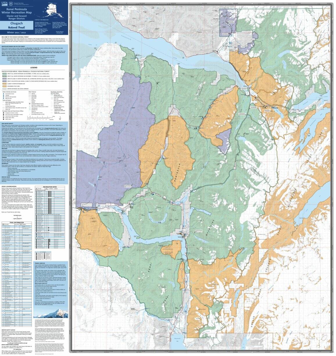
Along the Sterling Highway, winter access areas vary. From about the Russian River Campground to Cooper Creek, the area south of the Sterling Highway is closed to winter motorized use. South of the highway between Cooper Creek and the western end of Kenai Lake is open to all winter motorized use between Dec. 1 and April 30 if snow conditions allow. Large chunks of the Kenai Mountains are open to motorized winter use.

The U.S. Forest Service has a detailed map showing access in different parts of the forest published on Avenza Maps, a mobile app.

ADVERTISEMENT
0 seconds of 0 secondsVolume 0%
Press shift question mark to access a list of keyboard shortcuts
00:00
00:00
00:00
 

People recreating in the forest this winter are advised to exercise caution when crossing Alaska Railroad train tracks and to be prepared for adverse weather conditions, such as avalanche conditions. More information about avalanches can be found at www.chugachavalanche.org.

The U.S. Forest Service also reminds those recreating to respect private property and that reserving or roping off spaces in parking lots is prohibited.

More information about snowmachining in the Chugach National Forest, including a link to the Avenza map, can be found at fs.usda.gov/chugach/.

Reach reporter Ashlyn O’Hara at ashlyn.ohara@peninsulaclarion.com.

More in News

Foliage surrounds the Soldotna Police Department sign on Tuesday, Aug. 30, 2022, in Soldotna, Alaska. (Ashlyn O’Hara/Peninsula Clarion)
Soldotna OKs $170,000 for new police camera system

The existing system was purchased only during the last fiscal year, which ended June 30, 2024.

Winter Marshall-Allen of the Homer Organization for More Equitable Relations, Homer Mayor Rachel Lord, and Jerrina Reed of Homer PRIDE pose for a photo after the mayoral proclamation recognizing June as Pride Month on Tuesday, May 27 at the Cowles Council Chambers. (Photo courtesy of Winter Marshall-Allen)
City of Homer recognizes Pride Month, Juneteenth

Mayor Rachel Lord brought back the tradition of mayoral proclamations May 12.

File
Potential remains of missing Texas boaters discovered in sunken vessel

The vessel capsized 16 miles west of Homer in Kachemak Bay in August.

A sign for The Goods Sustainable Grocery is seen in Soldotna, Alaska, on Tuesday, May 20, 2025. (Jake Dye/Peninsula Clarion)
New Saturday Market to launch this summer at The Goods

The summer bazaar will feature craftspeople from around the central and southern Kenai Peninsula.

Council member Alex Douthit speaks during a meeting of the Kenai City Council in Kenai, Alaska, on Wednesday, June 5, 2024. (Jake Dye/Peninsula Clarion)
Kenai loosens restrictions on employee purchase of city property

Municipal officers like city council members are still prohibited from buying property.

Mount Spurr is seen from the Kenai Peninsula, Alaska, on May 11, 2025. (Peninsula Clarion file)
Likelihood of Spurr eruption continues to decline

Spurr is located about 61 miles away from Kenai and 117 miles away from Homer.

Anchor Point Chamber of Commerce President Dawson Slaughter (left) and Susie Myhill, co-owner of Anchor River Lodge and co-chair for the chamber’s sign committee, unveil the new “most westerly highway point” sign on Tuesday in Anchor Point. (Delcenia Cosman/Homer News)
Anchor Point chamber unveils new highway sign

The sign marks the “most westerly” highway point in North America.

Alaska State Troopers logo.
1 dead in Anchor River vehicle turnover

Alaska State Troopers were notified at 7:46 a.m. of a vehicle upside down in the Anchor River.

The barge, crane, and first pile of rock for the Kenai Bluff Stabilization Project is seen during a break in work at the bank of the Kenai River in Kenai, Alaska, on Tuesday, May 27, 2025. (Jake Dye/Peninsula Clarion)
Kenai bluff project underway

A roughly 5,000-foot-long berm will be constructed from the mouth of the Kenai River to near the city dock.

Most Read