
When the endangered Cook Inlet beluga whales strand, it can be a guessing game as to how many and how old they are. The National Oceanic and Atmospheric Administration will soon have a little help monitoring them.
The agency will use an unmanned aircraft system, also known as a drone, during strandings to gather more information about the whales. Alaska Aerial Media, a licensed drone pilot company based in Anchorage, will do the actual flying.
Barbara Mahoney, a biologist with NOAA who works with the Cook Inlet beluga whales, said the drones will offer more information about the whale or group of whales that is not available from a horizontal view, such as whether they are in a pool of water or partially submerged, which would improve their chances of surviving, she said.
“It would help us identify age class,” Mahoney said. “It would help identify groups. Sometimes they’re all in one group and other times they’re all spread out. And it provides us their location.”
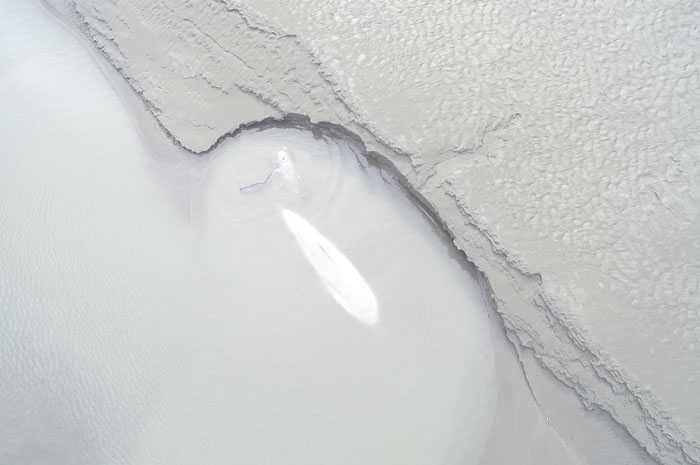
The drone is a cost-effective way of doing an aerial survey, she said. The pilots would have to drive out relatively close to where the whales are stranded and then launch the drone. It was tested on a pair of stranded belugas on a mudflat in the Turnagain Arm in August and brought back good images, she said.
Image quality can be a frustrating problem in an airplane, she said. When the strong winds in the Cook Inlet shake a plane, the photographer’s images can come out blurry.
“I think (the drones) do much better, picture-wise, for sure, in strong winds,” Mahoney said. “We had gusts of 40 miles per hour, and the pictures were great.”
One of the big goals is to have good enough image quality to make photo identifications. LGL Limited, an Anchorage-based environmental research company, has been conducting a beluga photo identification study for the past 10 years.
Better photos of belugas during strandings could contribute to that project and help researchers follow up on the welfare of a particular whale later, Mahoney said.
However, because the drones have to be driven fairly close and operated manually, flying them to a remote site would be impossible, so the drone operations are limited to the Turnagain and Knik arms. Whales don’t often strand on the West Side of Cook Inlet, but if one did, biologists would still have to rely on a plane or boat to reach it, Mahoney said.
The drones are one piece of a larger effort to restore the Cook Inlet belugas, which saw a drastic drop population in the 1990s and now number around 340. NOAA contracts with veterinarians both through the Alaska SeaLife Center in Seward and independently as well as encouraging outreach to raise public awareness of stranding events.
The Alaska Marine Mammal Stranding Network, a group of various agencies, veterinary clinics, Alaska Native organizations, academic institutions and individuals also help NOAA keep abreast of what is happening.
“There’s a good network of folks from Homer all the way up to Anchorage, and Tyonek is active as well at informing us,” Mahoney said. “And we’re conducting necropsies on all the dead whales to determine cause of death.”
Reaching the whales quickly, even if they are already dead, can be helpful for research. Determining cause of death is often impossible for the biologists performing the necropsies on dead whales because the tissue is too far gone. Learning what a whale died from may help identify more about the threats facing the Cook Inlet belugas, Mahoney said.
“Getting to the fresh animal would help with getting fresher samples,” Mahoney said. “That can help us determine what killed this particular animal and whether it’s a disease, which we can watch for, or a ship strike or an entanglement.”
Reach Elizabeth Earl at elizabeth.earl@peninsulaclarion.com.
