This section of a property ownership map shows some of Cook Inlet Region Incorporated’s lands along the Kenai River near Soldotna, with surface ownership depicted in dark red. CIRI has erected signs this year letting the public know where its privately owned lands are and asking people not to use them to fish without a permit, which is available for free through the corporation. (Courtesy Cook Inlet Region Incorporated)

This section of a property ownership map shows some of Cook Inlet Region Incorporated’s lands along the Kenai River near Soldotna, with surface ownership depicted in dark red. CIRI has erected signs this year letting the public know where its privately owned lands are and asking people not to use them to fish without a permit, which is available for free through the corporation. (Courtesy Cook Inlet Region Incorporated)

CIRI steps up enforcement on Kenai River lands

Kenai River anglers will have to keep an eye out for private property this year as Cook Inlet Region Incorporated steps up its efforts to protect its riverfront lands from damage.

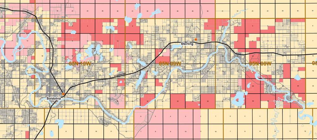
Cook Inlet Region Inc., the Alaska Native corporation that represents 8,800 shareholders and owns approximately 1.3 million acres of land scattered around Southcentral Alaska, is a major landowner along the Kenai River. The corporation’s lands there, all of which are undeveloped, make up approximately 7–8 percent of the riverfront property between the mouth and the border with the Kenai National Wildlife Refuge.

In recent years, corporation staff members have noticed a lot of habitat damage on the properties, and this year is stepping up enforcement to protect those lands, said Corporate Communications Director Jason Moore.

“(People are) dumping trash, cutting down wood, hurting the streambank, damaging the habitat … there’s a host of issues there that people just aren’t treating the property with much respect,” he said. “This is private property just like any other private property.”

Some of the areas exhibited fairly significant damage late last year, with trees cut down for firewood and weeds cut back from the bank or trampled. Corporation staff members have noticed the damage before but it has worsened, with some people spotting extensive camping and treecutting, Moore said.

There are several reasons the corporation wants to restrict access and damage to the land, one of which is liability for injury or accidents on private land, Moore said.

“Liability is a big issue, and most of the use is along the streambank,” he said. “That’s where we’re seeing much of the damage, if you will, and I think that’s when you look at the habitat problems, that’s the most risky areas for that damage too.”

Signs have gone up on CIRI’s lands to let people know that it is private property, Moore said. Though staff members won’t perform regular patrols, they’ll check in periodically and will call the troopers to enforce laws against trespassing if necessary.

One group the corporation will rely on to spot any abuse is the fishing guides, Moore said. Guides have dropped clients off on the banks in the past, and the corporation asked for them to keep an eye out for damage to the land.

The enforcement doesn’t mean private individuals can’t use the land at all — they just have to get a permit first. CIRI has a land permit available for recreational users for free through its website, which is open to everyone. Commercial users, including guides, can obtain commercial permits. Access is based on dates and users are asked to respect the corporation’s land use policies, according to its website.

Much of the land along the Kenai River is privately owned. Some sections of the river are divided up into dozens of small parcels, all with a small stretch of riverfront, where anglers and guides cannot fish or land boats without permission. The state and borough own some properties that allow for public access, such as the Donald E. Gilman River Center on Funny River Road. Moore said people may confuse CIRI land for public land because it is undeveloped, but the corporation hopes the signs will help make that clearer.

“Enforcement is not going to be easy, but I think a lot of this is the users probably don’t know what the land patterns are, the ownership patterns,” he said. “We’re hoping the signage could let them know that it’s not public land, it’s private land. I think most of the users out there are responsible and want to follow the rules.”

Reach Elizabeth Earl at elizabeth.earl@peninsulaclarion.com.

More in News

Low clouds hang over Cook Inlet north of Anchor Point on Oct. 23, 2025. (Photo by Yereth Rosen/Alaska Beacon)
Inletkeeper condemns federal management of Cook Inlet oil lease sale

The agency alleges an environmental study by the Bureau of Ocean Energy Management was conducted with a “serious” lack of transparency.

The Kenai Chamber of Commerce announced the winners of the 13th annual gingerbread house competition on Dec. 20, 2025. This creation by Sierra won the 2-5 year old age category. Photo courtesy of the Kenai Chamber of Commerce
Wrapping up the holiday season

The Kenai Chamber of Commerce’s Angel Tree program and gingerbread house competition spread Christmas cheer to hundreds locally.

The Challenger Learning Center is seen here in Kenai<ins>, Alaska,</ins> on Sept. 10, 2020. (Photo by Brian Mazurek/Peninsula Clarion)
Kenai City Council considers possible uses for Challenger Center

One option would assess the facility’s potential as the new public safety building.

A snowmachine rider takes advantage of 2 feet of fresh snow on a field down Murwood Avenue in Soldotna, Alaska, on Monday, Dec. 12, 2022. (Jake Dye/Peninsula Clarion)
Ice fishing opens on some Kenai National Wildlife Refuge lakes

Snowmachines are permitted for ice fishing access on Hidden, Kelly, Petersen, Engineer and Watson lakes.

The waters of Cook Inlet lap against Nikishka Beach in Nikiski, Alaska, where several local fish sites are located, on Friday, March 24, 2023. (Jake Dye/Peninsula Clarion)
Kenai asks for fishery economic disaster declaration

The Kenai City Council requested that Gov. Dunleavy declare a disaster and support a recovery plan for the Upper Cook Inlet East Side Set Net fishery.

The Kenai Peninsula Borough School District logo. (Photo courtesy of Kenai Peninsula Borough School District)
District superintendent dispels rumors about student construction

Superintendent Clayton Holland said student involvement in Seward High School construction is “based on rumor, not fact.”

Anchorage-based singer and songwriter Keeley Boyle is pictured in Anchorage<ins>, Alaska,</ins> on Sept. 26, 2023. Boyle, who was raised on the Kenai Peninsula, will use a $10,000 grant she received from the Rasmuson Foundation to create an album of songs about her grandparents’ home in Nikiski. Photo courtesy of Jovell Rennie
Musician hailing from Kenai receives Rasmuson grant

Keeley Boyle will record an album of songs about her grandparents’ Nikiski home.

Commercial fishing and recreational vessels are docked in the Homer harbor on Oct. 23, 2025. The commercial fishing industry endured a series of challenges over the year, some of them imposed by the new Trump administration. (Photo by Yereth Rosen/Alaska Beacon)
Alaska fisheries in 2025: turmoil, economic and environmental challenges and some bright spots

NOAA cuts, economic headwinds and invasive species pose problems, but there was some recovery in crab stocks and salmon harvests.

Cook Inlet near Clam Gulch is seen on Oct. 23, 2025. (Photo by Yereth Rosen/Alaska Beacon)
Disputed oil lease sale in Alaska’s Cook Inlet upheld in new Trump administration decision

After completing a court-ordered environmental study, the Bureau of Ocean Energy Management said no changes are needed for the 2022 sale that drew just one bid.

Most Read