Changing wind patterns move smoke into western part of the peninsula
Published 9:00 am Wednesday, August 28, 2019
As wind patterns shifted on the Kenai Peninsula this morning, fire crews from the Great Basin Incident Management Team are preparing to address additional areas along the Swan Lake Fire’s perimeter.
There will be a community meeting at 6 p.m. tonight to inform the public about current operations at the Cooper Landing School. To avoid driving on the Sterling Highway, residents are encouraged to watch the meeting live on the KPB Alerts Facebook page.
Delays along the Sterling Highway remain likely, and travel is not advised. The Kenai Peninsula Borough Office of Emergency Management has reported delays of up to three or four hours as pilot cars are taking vehicles on one lane through the fire area.
The eastern checkpoint on the Sterling Highway has been moved from the intersection of the Sterling and Seward Highways at mile 36 to mile 40 in order to reduce the turnaround time for pilot cars. Motorists are encouraged to plan ahead if traveling on the highway and to bring plenty of food and water.
The Alaska Department of Environmental Conservation has issued an Air Quality Advisory for the Kenai Peninsula that will be in effect through this afternoon. Light downslope winds have begun coming in from the east and southeast today, which will move some of the dense smoke west to Kenai, Soldotna, Nikiski and Sterling. According to the DEC Advisory, air quality will range from “unhealthy for sensitive groups” to “hazardous” on the peninsula, and people should avoid prolonged outdoor activities.
Crews will be monitoring the northwestern perimeter of the fire by air to keep an eye out for any fire growth in that area.
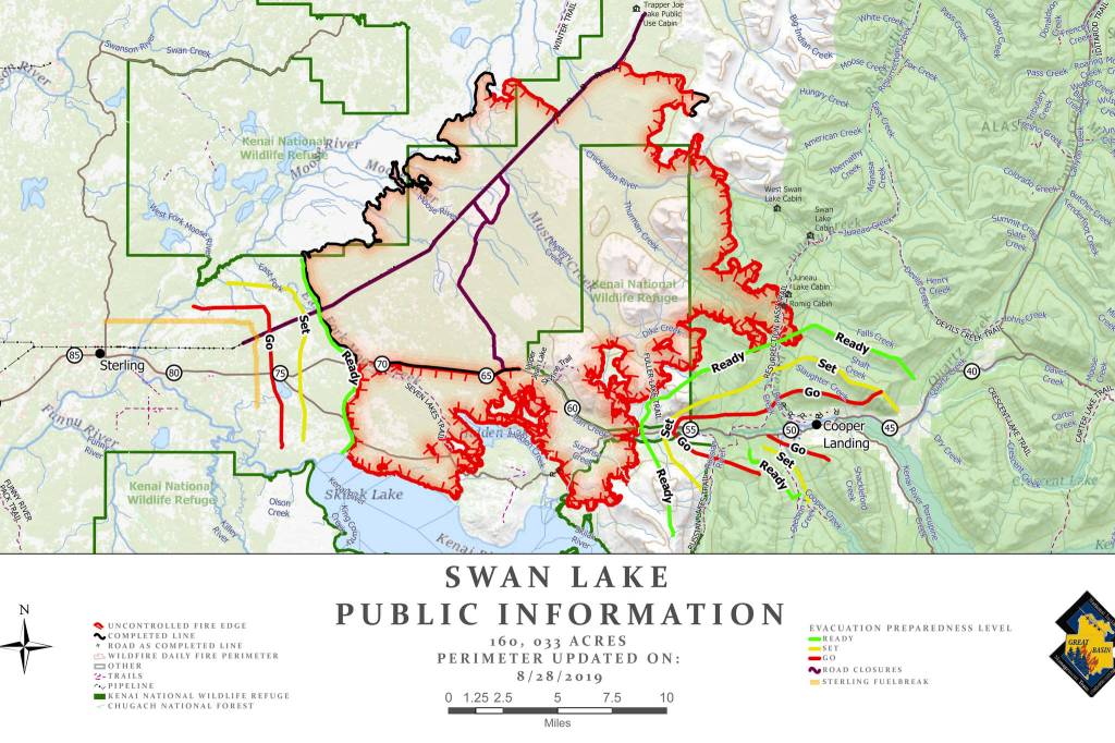
In a 9 a.m. live update this morning, Operations Section Chief Jeff Surber laid out the plans for the day and the areas of the fire’s perimeter that will be the focus of the day’s operations. The latest mapping of the fire puts it at 160,033 acres.
Crews stationed along the western perimeter of the fire are continuing to reinforce the western control line, and the fire has not grown any closer to Sterling since the control line was established. Surber said that crews in the area and infrared flights are reporting less and less heat in the area every day.
A large column of smoke originating near the Hidden Lake Campground was visible from the Sterling Highway yesterday. In response to this activity, crews conducted aerial water drops and constructed dozer lines near the campground. Structure protection tools including pump and sprinkler systems are in place at Kelly Lake, Engineer Lake and Upper Ohmer cabins as well as the Skilak Guard Station and the Hidden Lake Pavilion. Burnout operations will be implemented in the area today if they are deemed necessary to protect the campground’s infrastructure.
To the east of the campground, crews have completed mop up efforts and constructed a dozer line from Skilak Lake Road south to the Kenai River. Surber said that no advancement is predicted in this area.
Along the fire’s southeastern perimeter, four crews are pushing the containment line further into areas of lighter fuel in an effort to limit the fire’s growth towards Cooper Landing from the south side of the highway.
On Monday night the fire crossed the Resurrection Pass Trail into Slaughter Ridge, prompting the Borough’s Office of Emergency Landing to put Cooper Landing in “SET” status. Crews are working from Trout Lake today to combat the parts of the fire that crossed that containment line along Resurrection Pass Trail, and aerial water drops will be conducted when smoke conditions are clear enough.
A swing shift crew working from 10 a.m. to midnight will be creating an additional contingency line north of Cooper Landing to limit the potential of the fire spreading south from its current location near Slaughter Ridge.
Cooper Landing remains in “SET” status as of this morning. Being in “SET” status is not a notice to evacuate, but residents should make all the preparations necessary to evacuate if the situation calls for it.
Structure protection crews will continue to work within the community of Cooper Landing by installing sprinklers and hose lines around homes and businesses. In addition, a night-shift crew consisting of four fire engines will conduct patrols along the Sterling Highway to keep an eye out for any new fire behavior.
Active fire behavior remains likely until there is a significant change in the weather pattern. A low pressure weather pattern could come into the area this weekend, which would bring cooler temperatures and precipitation as early as Friday night. Precipitation on and off is possible through the middle of next week.
For the latest information on fire activity, visit kpboem.com or call the borough’s call center at 907-262-INFO (4636)