
A state board tasked with drawing legislative boundary maps will tour the state this month — with stops on the Kenai Peninsula — to solicit input from the public on how to divide the state’s population following the 2020 census.
The Alaska State Redistricting Board will collect public input on six maps. It isn’t guaranteed that one of the six maps will be the final version, however, because the board could use input solicited during the tour to help craft an entirely new map.
In addition to two maps submitted by the board, four maps were submitted by third parties and approved for consideration by the board. Third-party maps approved for consideration were submitted by the Doyon Coalition, Alaskans For Fair Redistricting (AFFR), Alaskans For Fair and Equitable Redistricting (AFFER) and the Alaska Senate Minority Caucus.
Earlier this year, the exact timeline for Alaska’s redistricting process was unclear because of a delay in the release of 2020 data from the U.S. Census Bureau. That data was released on Aug. 12 and the board is required to adopt for consideration at least one map within 30 days of the data being released. The board is composed of five people, who are appointed by the governor, the Alaska Senate president, speaker of the Alaska House of Representatives and the chief justice of the Alaska Supreme Court. More information about each of the five board members can be found on the board’s website.
Criteria for drawing state legislative districts is outlined in the Alaska Constitution, which says that districts must be contiguous and compact in addition to being equal in population size with socioeconomic integration. Legal explanations and definitions for each of those phrases have been fleshed out by the Alaska Supreme Court in cases heard between 1972 and 2012.
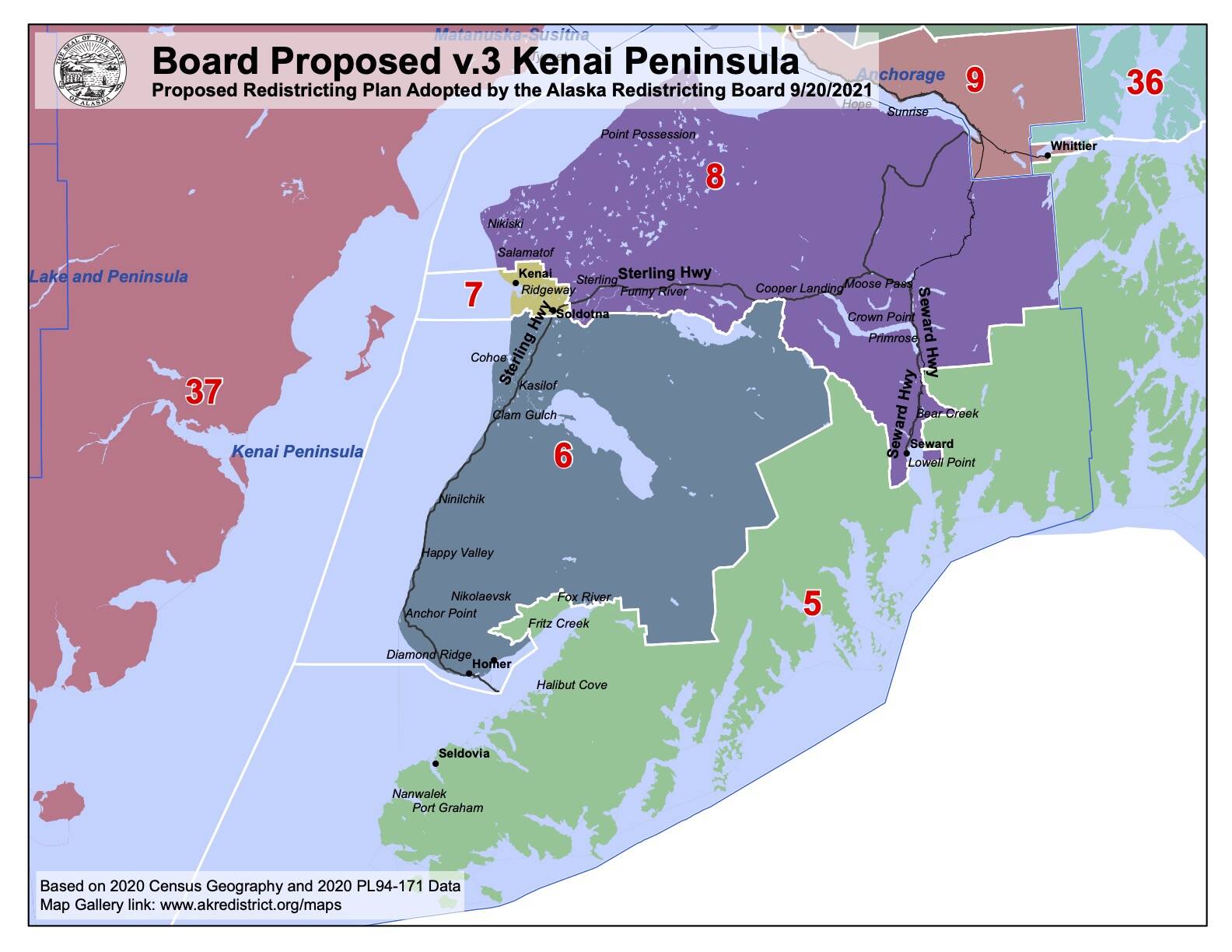
Alaska had a population of about 733,391 according to the 2020 census. Alaska’s constitution describes 40 legislative districts, meaning that each district should be drawn such that it contains as close to 18,335 people as possible.
Currently, the Kenai Peninsula is divided into four state House districts and two state Senate districts. Sen. Peter Micciche represents state Senate District O, which includes most of the peninsula north of Skilak Lake and parts of the eastern peninsula including Seward and Funny River. Sen. Gary Stevens represents state Senate District P, which includes most of the peninsula south of Funny River, including Kasilof, Homer and communities across Kachemak Bay including Nanwalek and Seldovia.
Rep. Ben Carpenter represents state House District 29, which includes most of the northern peninsula, including Nikiski, Seward, Hope and Sterling. Rep. Ron Gillham represents state House District 30, which includes Kenai and Soldotna. Rep. Sarah Vance represents state House District 31, which includes Homer and the southern peninsula. Rep. Louise Stutes represents state House District 32, which includes communities across Kachemak Bay and Kodiak Island.
Proposed changes to the legislative makeup of the Kenai Peninsula range broadly between the six different plans up for consideration.
The plan proposed by the Alaska Senate Minority Caucus would divide the peninsula into five state House seats instead of four. Under that plan, Moose Pass residents would vote in the same state House district as people in Girdwood and Whittier. The plan proposed by AFFER would connect Nikiski and communities along Turnagain Arm including Girdwood and south Anchorage.
The Doyon plan would put Seward voters in the same district as voters on Kodiak Island. The AFFR plan would group voters south of the Kenai River and west of Tustumena Lake south until about Stariski State Recreational Site.
Public comments on any of the six maps up for consideration by the redistricting board, as well as additional information on the state’s redistricting process and maps showing the boundaries proposed by all six plans can be found at akredistrict.org.
Reach reporter Ashlyn O’Hara at ashlyn.ohara@peninsulaclarion.com.
