A map of the areas proposed for annexation by the City of Soldotna. (Courtesy Alaska Department of Commerce)

A map of the areas proposed for annexation by the City of Soldotna. (Courtesy Alaska Department of Commerce)

Annexation comments open until June 19

The annexation proposal would add 2.63 square miles to Soldotna’s existing boundaries.

Kenai Peninsula residents in and around the city of Soldotna have until June 19 to submit their comments on the preliminary report regarding Soldotna’s petition to annex 2.63 square miles of land near the city.

Staff for the state’s Local Boundary Commission released their preliminary report on the annexation petition on May 18, stating in the 32-page report that the petition meets the state’s standards for annexation and recommending that the LBC approve the petition as presented.

“Local Boundary Commission staff recommends approval of the petition as presented because the services currently provided by the City of Soldotna can be reasonably and efficiently extended to the annexed territory, an area where residents and businesses are already receiving the benefits of city services,” the report reads

ADVERTISEMENT
0 seconds of 0 secondsVolume 0%
Press shift question mark to access a list of keyboard shortcuts
00:00
00:00
00:00
 

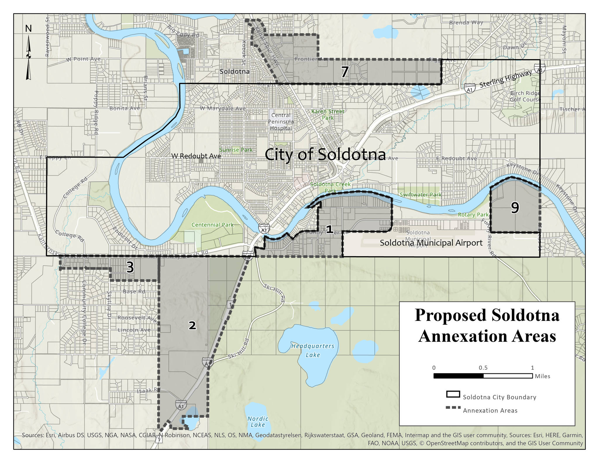
The annexation proposal would add 2.63 square miles to the city’s existing boundaries and would incorporate five distinct areas along Funny River Road, Kalifornsky Beach Road, the Kenai Spur Highway and the Sterling Highway.

During the process of writing the preliminary report, LBC staff received public comments from 19 people, with 15 opposed and four in favor of annexation.

Public comment on the results of the preliminary report will be received until 4:30 p.m. on June 19. Comments can be emailed to lbc@alaska.gov or mailed to the following address:

Local Boundary Commission staff

Division of Community and Regional Affairs

550 W. 7th Ave. Suite 1640

Anchorage, AK 99501

A final report and second recommendation will be issued by LBC staff on or around July 20 of this year. Following the release of the final report, the Local Boundary Commission will conduct a public hearing on the petition in August.

More in News

Foliage surrounds the Soldotna Police Department sign on Tuesday, Aug. 30, 2022, in Soldotna, Alaska. (Ashlyn O’Hara/Peninsula Clarion)
Soldotna OKs $170,000 for new police camera system

The existing system was purchased only during the last fiscal year, which ended June 30, 2024.

Winter Marshall-Allen of the Homer Organization for More Equitable Relations, Homer Mayor Rachel Lord, and Jerrina Reed of Homer PRIDE pose for a photo after the mayoral proclamation recognizing June as Pride Month on Tuesday, May 27 at the Cowles Council Chambers. (Photo courtesy of Winter Marshall-Allen)
City of Homer recognizes Pride Month, Juneteenth

Mayor Rachel Lord brought back the tradition of mayoral proclamations May 12.

File
Potential remains of missing Texas boaters discovered in sunken vessel

The vessel capsized 16 miles west of Homer in Kachemak Bay in August.

A sign for The Goods Sustainable Grocery is seen in Soldotna, Alaska, on Tuesday, May 20, 2025. (Jake Dye/Peninsula Clarion)
New Saturday Market to launch this summer at The Goods

The summer bazaar will feature craftspeople from around the central and southern Kenai Peninsula.

Council member Alex Douthit speaks during a meeting of the Kenai City Council in Kenai, Alaska, on Wednesday, June 5, 2024. (Jake Dye/Peninsula Clarion)
Kenai loosens restrictions on employee purchase of city property

Municipal officers like city council members are still prohibited from buying property.

Mount Spurr is seen from the Kenai Peninsula, Alaska, on May 11, 2025. (Peninsula Clarion file)
Likelihood of Spurr eruption continues to decline

Spurr is located about 61 miles away from Kenai and 117 miles away from Homer.

Anchor Point Chamber of Commerce President Dawson Slaughter (left) and Susie Myhill, co-owner of Anchor River Lodge and co-chair for the chamber’s sign committee, unveil the new “most westerly highway point” sign on Tuesday in Anchor Point. (Delcenia Cosman/Homer News)
Anchor Point chamber unveils new highway sign

The sign marks the “most westerly” highway point in North America.

Alaska State Troopers logo.
1 dead in Anchor River vehicle turnover

Alaska State Troopers were notified at 7:46 a.m. of a vehicle upside down in the Anchor River.

The barge, crane, and first pile of rock for the Kenai Bluff Stabilization Project is seen during a break in work at the bank of the Kenai River in Kenai, Alaska, on Tuesday, May 27, 2025. (Jake Dye/Peninsula Clarion)
Kenai bluff project underway

A roughly 5,000-foot-long berm will be constructed from the mouth of the Kenai River to near the city dock.

Most Read