In this Sunday, March 27, 2016, photo, Pavlof Volcano, one of Alaska's most active volcanoes, erupts, sending a plume of volcanic ash into the air. The Alaska Volcano Observatory says activity continued Monday. Pavlof Volcano is 625 miles southwest of Anchorage on the Alaska Peninsula, the finger of land that sticks out from mainland Alaska toward the Aleutian Islands. (Colt Snapp via AP) MANDATORY CREDIT

In this Sunday, March 27, 2016, photo, Pavlof Volcano, one of Alaska's most active volcanoes, erupts, sending a plume of volcanic ash into the air. The Alaska Volcano Observatory says activity continued Monday. Pavlof Volcano is 625 miles southwest of Anchorage on the Alaska Peninsula, the finger of land that sticks out from mainland Alaska toward the Aleutian Islands. (Colt Snapp via AP) MANDATORY CREDIT

Alaska volcano ash cloud covers 400 miles, cancels flights

  • By Dan Joling
  • Monday, March 28, 2016 9:35pm
  • News

ANCHORAGE, Alaska — Strong winds Monday pushed an ash cloud from an Alaska volcano into the heart of the state, grounding flights and limiting travel to western and northern communities off the road system.

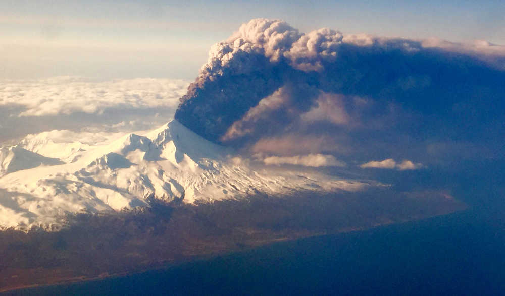
Pavlof Volcano, one of Alaska’s most active volcanoes, is 625 miles southwest of Anchorage on the Alaska Peninsula, the finger of land that sticks out from mainland Alaska toward the Aleutian Islands.

The volcano in the 8,261-foot mountain erupted about 4 p.m. Sunday, spitting out an ash cloud that rose to 20,000 feet.

ADVERTISEMENT
0 seconds of 0 secondsVolume 0%
Press shift question mark to access a list of keyboard shortcuts
00:00
00:00
00:00
 

Lightning over the mountain and pressure sensors indicated eruptions continued overnight By 7 a.m. Monday, the ash cloud had risen to 37,000 feet and winds to 50 mph or more had stretched it over more than 400 miles into interior Alaska.

“It’s right in the wheelhouse of a lot of flights crisscrossing Alaska,” said geologist Chris Waythomas, of the U.S. Geological Survey, part of the Alaska Volcano Observatory, along with the University of Alaska and the state Division of Geological and Geophysical Surveys.

Alaska Airlines before noon cancelled 20 flights affecting about 1,300 customers heading to Bethel, Kotzebue, Nome, Barrow and Deadhorse, spokeswoman Bobbie Egan said.

No flights to Anchorage or Fairbanks had been canceled, but Egan said the company was closely monitoring the Fairbanks route.

Volcanic ash is angular and sharp and has been used as an industrial abrasive. The powdered rock can cause a jet engine to shut down. USGS geologists have compared it to flying into a sand blaster.

An eruption of Mount Redoubt in December 1989 sent out an ash cloud 150 miles that flamed out the jet engines of a KLM flight carrying 231 passengers to Anchorage. The jet dropped more than two miles before pilots were able to restart the engines and land safely.

“We just simply will not fly when ash is present,” Egan said.

Waythomas had received no reports of ash falling in communities. The closest community, Cold Bay, is 37 miles southwest of the volcano, opposite of where the wind was blowing ash.

Geologists call Pavlof an open-system volcano, Waythomas said.

“The pathways that magma follows to the surface are pretty open in a volcanological sense,” Waythomas said. “They can convey magma and gas very easily. Magmas can move to the surface whenever they feel like it, more or less.”

The movement comes with little shaking of the ground, and the lack of earthquakes as an early warning of an eruption “makes us go crazy monitoring them,” Waythomas said.

The volcano, about 4.4 miles in diameter, has had 40 known eruptions.

Its conical, nearly symmetrical shape indicates its eruptions tend to be less violent than the kind that blows tops off mountains.

“It can erupt for periods of hours to days or it can go on for much longer periods of time,” Waythomas said. “It won’t erupt continuously for many months or a year. It will be intermittent. But the eruption cycle could go on for a while, or it could abruptly shut off and be done tomorrow.”

The USGS raised the volcano alert to its highest level, which warns of hazards both in the air and on the ground.

This story has been corrected to show the volcano is on the Alaska Peninsula, not in the Aleutian Islands.

More in News

Foliage surrounds the Soldotna Police Department sign on Tuesday, Aug. 30, 2022, in Soldotna, Alaska. (Ashlyn O’Hara/Peninsula Clarion)
Soldotna OKs $170,000 for new police camera system

The existing system was purchased only during the last fiscal year, which ended June 30, 2024.

Winter Marshall-Allen of the Homer Organization for More Equitable Relations, Homer Mayor Rachel Lord, and Jerrina Reed of Homer PRIDE pose for a photo after the mayoral proclamation recognizing June as Pride Month on Tuesday, May 27 at the Cowles Council Chambers. (Photo courtesy of Winter Marshall-Allen)
City of Homer recognizes Pride Month, Juneteenth

Mayor Rachel Lord brought back the tradition of mayoral proclamations May 12.

File
Potential remains of missing Texas boaters discovered in sunken vessel

The vessel capsized 16 miles west of Homer in Kachemak Bay in August.

A sign for The Goods Sustainable Grocery is seen in Soldotna, Alaska, on Tuesday, May 20, 2025. (Jake Dye/Peninsula Clarion)
New Saturday Market to launch this summer at The Goods

The summer bazaar will feature craftspeople from around the central and southern Kenai Peninsula.

Council member Alex Douthit speaks during a meeting of the Kenai City Council in Kenai, Alaska, on Wednesday, June 5, 2024. (Jake Dye/Peninsula Clarion)
Kenai loosens restrictions on employee purchase of city property

Municipal officers like city council members are still prohibited from buying property.

Mount Spurr is seen from the Kenai Peninsula, Alaska, on May 11, 2025. (Peninsula Clarion file)
Likelihood of Spurr eruption continues to decline

Spurr is located about 61 miles away from Kenai and 117 miles away from Homer.

Anchor Point Chamber of Commerce President Dawson Slaughter (left) and Susie Myhill, co-owner of Anchor River Lodge and co-chair for the chamber’s sign committee, unveil the new “most westerly highway point” sign on Tuesday in Anchor Point. (Delcenia Cosman/Homer News)
Anchor Point chamber unveils new highway sign

The sign marks the “most westerly” highway point in North America.

Alaska State Troopers logo.
1 dead in Anchor River vehicle turnover

Alaska State Troopers were notified at 7:46 a.m. of a vehicle upside down in the Anchor River.

The barge, crane, and first pile of rock for the Kenai Bluff Stabilization Project is seen during a break in work at the bank of the Kenai River in Kenai, Alaska, on Tuesday, May 27, 2025. (Jake Dye/Peninsula Clarion)
Kenai bluff project underway

A roughly 5,000-foot-long berm will be constructed from the mouth of the Kenai River to near the city dock.

Most Read