
My interest in the Russian River fishery was suddenly piqued one day about four years ago, when a colleague, Paul Ruesch, asked me a very intriguing question: Could there be a geologic reason for the two genetically diverse sockeye salmon populations in the Russian River drainage?
My initial response was: What do you mean by genetically diverse sockeye stocks in Russian River? Paul, a retired Alaska Fish and Game fishery biologist, was ready with the answer—genetic studies demonstrate that the DNA is different in salmon spawning above and below the falls in Russian River.
A couple of days later, he showed me a complicated-looking diagram that illustrates genetic relations between red salmon that spawn in different Cook Inlet drainages, including Russian River. Simply put, closely related sockeye stocks plot close together in that diagram, and stocks that are not closely related plot far apart. At the top of the diagram, Paul pointed out a population of sockeyes that spawns above the Russian River falls during early and late runs, and the adults are small relative to adult reds that spawn below the falls. I later learned that those red salmon overwinter in the Upper and Lower Russian lakes. In the lower third of the diagram, Paul then indicated a population of red salmon that spawns during the late run below the falls and clusters with other sockeyes spawning in the Upper Kenai River. Those reds overwinter in Skilak Lake.
Actually, the relation of fish distribution to geologic factors has intrigued me since my graduate-school days, when I was assigned to read a classic 1948 paper by Carl Hubbs and Robert Miller on the zoological evidence relating fish distributions and drainage changes in the desert southwestern US. So, I was preprogrammed to try and answer Paul’s initial question.
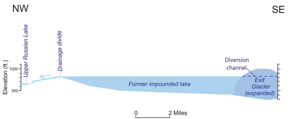
A guiding principle of my geologic studies is to understand the big picture first, so I initially studied the 1:250,000-scale topographic map of the Seward Quadrangle, where the Russian River, a north-flowing tributary of the Upper Kenai River, is confined in an intensely glaciated mountain valley. I located the Russian River falls, Lower Russian Lake, and Upper Russian Lake, and I noted that the uppermost Russian River is separated by a low drainage divide at ~850 feet elevation from nearby Summit Creek, the uppermost tributary of Resurrection River, which drains southeastward into Resurrection Bay near Seward. Could red salmon somehow have crossed the divide from Resurrection River into Russian River?
Further examination of the topographic map revealed that Exit Glacier near Seward is positioned so that a significantly larger glacier would dam Resurrection River, impounding a large lake upstream of the glacier barrier and potentially trapping sockeyes during a spawning run. If lake level reached ~850 feet elevation, lake waters would decant across the drainage divide and enter the Russian River drainage, carrying along the red salmon trapped in the lake. Could I find evidence for the damming of the Resurrection River by Exit Glacier?
I next looked at aerial photographs of the Exit Glacier area and examined the area stereoscopically, so that I got a good 3-dimensional impression of the topography there. Sure enough, on the northeastern side of the Resurrection River valley across from the modern terminus of Exit Glacier, there is an obvious bedrock channel at ~850 feet elevation through which the river could have been diverted if the valley was blocked by an expanded Exit Glacier. Preparing a model (see graphic) showing the relations of the glacier/lake/drainage system was pretty straight forward.
Unfortunately, I lack the information to date the diversion of Resurrection River reds into the Kenai River drainage. An informed guess is that a larger Exit Glacier likely blocked the Resurrection River near the end of the last major glacial recession, perhaps 11,000 to 12,000 years ago.
I have not proven that such mixing of sockeye populations actually occurred in the manner I propose. Ideally, the model could be tested by comparing the DNA of the Russian River reds with sockeye salmon that spawn today in Resurrection River. Unfortunately, I learned that the modern runs of red salmon in Resurrection River are not native to that drainage, but are composed of a mixture of fish from several different drainages that were initially reared in the Trail Lake hatchery near Moose Pass. So the DNA of those fish cannot be used to test my hypothesis.
Geologic investigations often reach an impasse like this, where the available data are inadequate to provide a definitive solution. Optimists, like me, anticipate that future geologists and geneticists will eventually find the information needed to verify or refute this particular drainage model.
Dr. Dick Reger graduated from Kenai Territorial High School in 1957, and eventually earned a PhD in geology from Arizona State University. He co-authored a 2007 guidebook on the late Quaternary history of the Kenai Peninsula (http://www.dggs.alaska.gov/publications). You can find more information about the Kenai National Wildlife Refuge at http://kenai.fws.gov or http://www.facebook.com/kenainationalwildliferefuge.
