A magnitude 4.7 earthquake struck 13 miles north of Mount Iliamna on the western side of the Kenai Peninsula on Wednesday, March 23, 2022, in Alaska. (Screenshot/The Alaska Earthquake Center)

A magnitude 4.7 earthquake struck 13 miles north of Mount Iliamna on the western side of the Kenai Peninsula on Wednesday, March 23, 2022, in Alaska. (Screenshot/The Alaska Earthquake Center)

4.7 magnitude earthquake strikes north of Iliamna

Mount Iliamna is an active volcano on the west side of Cook Inlet

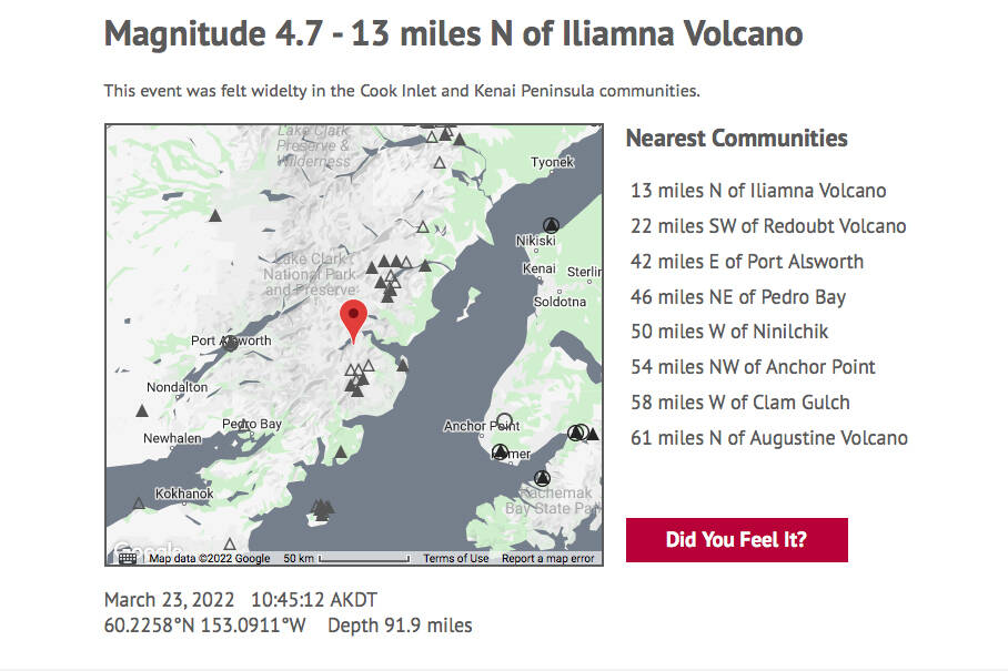
A 4.7 magnitude earthquake shook Kenai Peninsula communities at 10:45 a.m. Wednesday morning, according to the Alaska Earthquake Center.

The epicenter of the temblor struck just 13 miles north of Mount Iliamna, which is an active volcano on the west side of Cook Inlet.

A magnitude 5.1 earthquake struck the western side of Cook Inlet on March 12, centered 31 miles northwest of Kenai and 31 miles northeast of the Mount Redoubt volcano. A 3.6 magnitude earthquake struck 29 miles northeast of Kenai at a depth of 28 miles on March 8.

Wednesday’s tremor near Iliamna hit at a depth of 92 miles.

ADVERTISEMENT
0 seconds of 0 secondsVolume 0%
Press shift question mark to access a list of keyboard shortcuts
00:00
00:00
00:00
 

According to the earthquake center, strong quakes in southern Alaska are caused by the subducting Pacific and overriding North American tectonic plates. The second-largest rattle ever recorded worldwide struck under Prince William Sound in 1964. That earthquake was 9.2 on the Richter scale.

Some less devastating shakes are caused by the subducting Pacific Plate descending toward the mantle beneath the North American Plate. This zone of seismic activity extends from the Aleutian Arc to the Alaska Peninsula and Cool Inlet, where it ends underneath the northern foothills of the Alaska Range.

There were five other temblors on the Kenai Peninsula on Wednesday, as of 5 p.m.: a 1.9 magnitude in Clam Gulch, a 1.2 in Tyonek, a 1.1 in Nikiski, a 1.9 in Whittier and a 1.5 in Ninilchik.

Reach reporter Camille Botello at camille.botello@peninsulaclarion.com.

More in News

Foliage surrounds the Soldotna Police Department sign on Tuesday, Aug. 30, 2022, in Soldotna, Alaska. (Ashlyn O’Hara/Peninsula Clarion)
Soldotna OKs $170,000 for new police camera system

The existing system was purchased only during the last fiscal year, which ended June 30, 2024.

Winter Marshall-Allen of the Homer Organization for More Equitable Relations, Homer Mayor Rachel Lord, and Jerrina Reed of Homer PRIDE pose for a photo after the mayoral proclamation recognizing June as Pride Month on Tuesday, May 27 at the Cowles Council Chambers. (Photo courtesy of Winter Marshall-Allen)
City of Homer recognizes Pride Month, Juneteenth

Mayor Rachel Lord brought back the tradition of mayoral proclamations May 12.

File
Potential remains of missing Texas boaters discovered in sunken vessel

The vessel capsized 16 miles west of Homer in Kachemak Bay in August.

A sign for The Goods Sustainable Grocery is seen in Soldotna, Alaska, on Tuesday, May 20, 2025. (Jake Dye/Peninsula Clarion)
New Saturday Market to launch this summer at The Goods

The summer bazaar will feature craftspeople from around the central and southern Kenai Peninsula.

Council member Alex Douthit speaks during a meeting of the Kenai City Council in Kenai, Alaska, on Wednesday, June 5, 2024. (Jake Dye/Peninsula Clarion)
Kenai loosens restrictions on employee purchase of city property

Municipal officers like city council members are still prohibited from buying property.

Mount Spurr is seen from the Kenai Peninsula, Alaska, on May 11, 2025. (Peninsula Clarion file)
Likelihood of Spurr eruption continues to decline

Spurr is located about 61 miles away from Kenai and 117 miles away from Homer.

Anchor Point Chamber of Commerce President Dawson Slaughter (left) and Susie Myhill, co-owner of Anchor River Lodge and co-chair for the chamber’s sign committee, unveil the new “most westerly highway point” sign on Tuesday in Anchor Point. (Delcenia Cosman/Homer News)
Anchor Point chamber unveils new highway sign

The sign marks the “most westerly” highway point in North America.

Alaska State Troopers logo.
1 dead in Anchor River vehicle turnover

Alaska State Troopers were notified at 7:46 a.m. of a vehicle upside down in the Anchor River.

The barge, crane, and first pile of rock for the Kenai Bluff Stabilization Project is seen during a break in work at the bank of the Kenai River in Kenai, Alaska, on Tuesday, May 27, 2025. (Jake Dye/Peninsula Clarion)
Kenai bluff project underway

A roughly 5,000-foot-long berm will be constructed from the mouth of the Kenai River to near the city dock.

Most Read