
After considering several possible paths for a new highway section around Cooper Landing, the Alaska Department of Transportation named its preferred path for the new road on Friday.
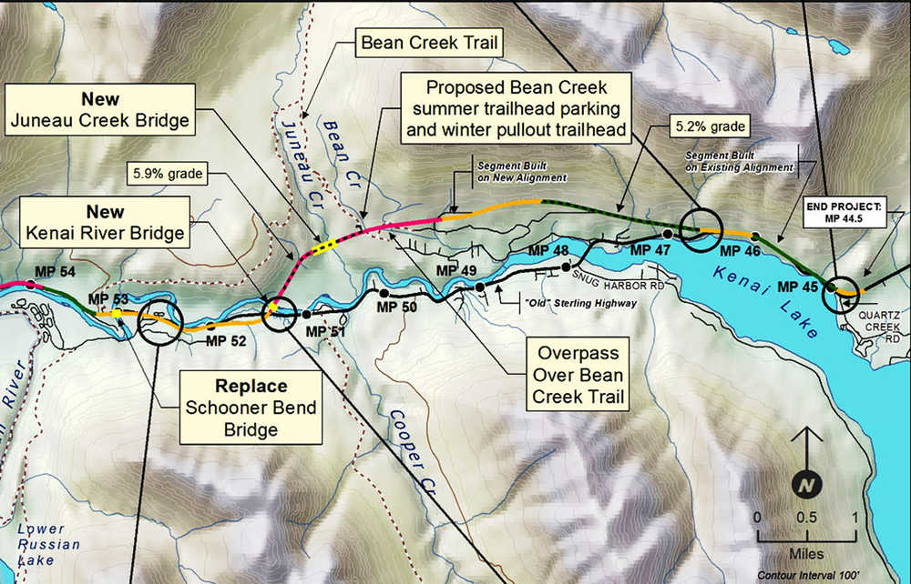
The proposed 5.5-mile bypass will depart from the existing Sterling Highway around milepost 52 in Cooper Landing and cross to the north side of the Kenai River via a bridge to be constructed about a half-mile east of that point. A second new bridge will take it over Juneau Creek, and on the north shore of Kenai Lake it will connect with the existing highway around milepost 46.
Passing through uphill land to the north of Cooper Landing, the proposed alternative will avoid a section of the present Sterling Highway that is winding, narrow, and slow. The speed limit of this section is 35 miles per hour, encouraged by Cooper Landing residents whose homes and businesses sit close to the highway with signs that read “We drive 35.”
On either end of the new bypass, existing highway will also be replaced for a distance totalling 8 miles. Department of Transportation spokes person Shannon McCarthy said the road’s age makes it less safe.
“The road itself is fairly old, both in its actual age and its design age,” McCarthy said. “This section of the Sterling doesn’t meet modern highway design (standards). It doesn’t have adequate shoulders, it doesn’t have a good clear zone, which you find on most modern highways.”
Clear zones are empty space bordering a highway, which McCarthy said are important because “if someone did leave the road for some reason, we’d want that vehicle to be able to come to a stop safely without hitting an obstacle or a steep embankment that might flip a car.”
An existing bridge crossing the Kenai River near milepost 53, labeled on a Department of Transportation map as the Schooner Bend Bridge, will also be replaced.
The Department of Transportation has been studying Cooper Landing bypass proposals since at least 1994, according to previous Clarion reporting. At that time, the department named a preferred route that passed through wilderness areas. According to McCarthy, the new preference does not have that problem.
“The routing avoids impacts to the Resurrection Pass Trail, the Juneau Falls Recreation Area and important cultural properties, and avoids using designated wilderness land within the Kenai National Wildlife Refuge,” McCarthy wrote in a press release. According to the project’s draft supplemental environmental impact statement, the road will affect 126 acres of Kenai Peninsula Borough Land, 90 acres of federal land, and 43 acres of state land. Less than 1 acre of private property will be affected.
Kenaitze Tribe Director of Tribal Governmental Affairs Alexandra “Sasha” Lindgren said one of the “important cultural properties” referred to in the release is the Squilantnu archeological district, a site near the confluence of the Russian River boat launch that was once the site of a Dena’ina crematorium were remains were found in the late 1980s. Lingren said the Kenaitze tribe had since reburied those remains in unmarked locations nearby. Although the Department of Transportation’s selected path did not come near it, an alternative considered earlier would have gone “right down the middle of that site,” according to Lindgren. She said the choice of a different route was a result of successful negotiation.
“Did they listen to us? Yes,” Lindgren said. “The consultation process … is going very well.”
Lindgren said the Kenaitze tribe would take an official position on the proposed route during a tribal council meeting next week, and will speak later to Department of Transportation officials as one of the four members of a Russian River stakeholder’s group that also includes the Native Corporation Cook Inlet Region Incorporated, the National Fish and Wildlife Service, and the National Forest Service. Lindgren said there are likely undiscovered artifacts remaining in the area.
“There’s a lot of study, a lot of work that needs to be done,” Lindgren said.
The new section of the road will cross the Bean Creek hiking trail. McCarthy said the department has yet to decide how, saying it was a decision “we will address in the design process.”
According to the impact statement, the Department of Transportation estimated the road will cost $303.5 million to build, and $23.8 million to maintain over 20 years.
It is still possible that the route could change before the Federal Highway Administration makes a final decision, which according to the press release, is expected in 2016. McCarthy said there will be an opportunity for the public to submit comments before the decision.
“Both the Alaska Department of Transportation and the Federal Highway Administration identified this as the alternative they’d like to explore further,” McCarthy said. “What you’ll see is perhaps some tweaks to it, but moving forward, I think this alternative is the one they’ll build up and explore in terms of design.”
After design and federal environmental permitting, the road could be constructed in 2018.
Reach Ben Boettger at ben.boettger@peninsulaclarion.com.
