Refuge Notebook: Geology of the Kenai … it rocks!
Published 10:30 pm Wednesday, October 13, 2021


One thing that never ceases to amaze me about living in Alaska is how much you can learn about the world around you. After two years, I find myself noticing things I would have immediately overlooked before.
Now on any walk, when I pass a tree I think, “Oh, that’s an alder,” see a berry and know, “That’s not quite ready to pick,” and view a lake to wonder, “Is that formed from an ice mass or is it from the glacier itself?”
Last semester I was tasked with a term project for my master’s class on geology. The topic was a no-brainer-of course, I chose my home and favorite office here at the Kenai National Wildlife Refuge. It also allowed me a great opportunity to learn more about the geology here on the peninsula that I now get to share.
First, let’s talk glaciers. A few types of glaciers on the peninsula are mountain glaciers (which flow from high to low) and ice caps (mounds of ice that submerge peaks). At one point, all of Alaska and the Kenai Peninsula were covered in ice, with a large ice cap covering the Kenai Mountains. There is evidence showing that the ice advanced and melted a total of seven times!
Moraines of the last three ice ages remain in Kenai lowlands between the mountains and the City of Soldotna. Moraines are materials left behind by a moving glacier, typically soil and rock. Soldotna and Kenai lowlands are covered in glacial deposits making up a glacial depositional landscape of till, outwash and lake beds.
Today, the only remainder of that ice sheet is seen in the Harding Icefield, a massive entity covering over 700 square miles. Some of us have seen the icy mass while hiking Kenai Fjords National Park’s Harding Icefield Trail or up in the air from a plane.
The last major glaciation period to cover the Kenai Peninsula was the Wisconsin Glaciation (part of the Quaternary period), occurring around 85,000 to 11,000 years ago. The most recent of this period was the Naptown Glaciation, which had four major advances, called stades, and retreats, named Moosehorn, Killey, Skilak, and Elmendorf (in order from oldest to youngest).
During the advancement of the Moosehorn stade (32,000 to 23,000 years ago), glaciers from the Kenai Mountains adjoined those of the Alaska Range across Cook Inlet. During its retreat, it formed the modern lower courses of the Kenai and Swanson rivers.
During the retreat of the Killey stade (18,500 to 17,500 years ago), the inlet was flooded with salt water, and the glaciers near the Cook Inlet retreated north, away from the peninsula. After advancing glaciers slightly, the retreat of the Skilak stade (17,500 years ago) confirmed the modern forms of the Kenai and Swanson Rivers, and Cook Inlet opened to Anchorage.
The last retreat of the Elmendorf stade (11,000 years ago) affected very little on the peninsula, though its retreat allowed plants and animals to return to the area.
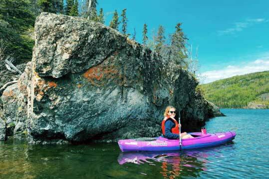
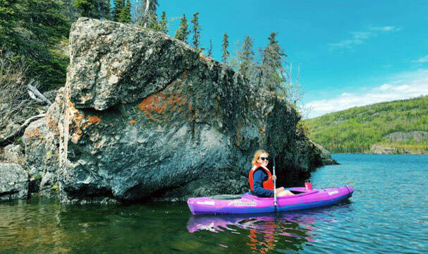
Skilak Lake sits in a terminal moraine created during the Skilak stade of the Naptown Glaciation and receding of the Skilak Glacier. Ice from the Upper Kenai River expanded to Mystery Creek. It then built nested moraines that now enclose Upper and Lower Fuller Lakes.
The small lake north of Skilak Lake is called Hidden Lake. It sits in a moraine created by the Hidden Lake glacial lobe during the Skilak stade of the Naptown Glaciation. End moraines and outwash, ridgelike debris marking the outermost edge of a glacier, led to leftover dead ice masses which produced large depressions.
These large depressions later formed the smaller Kelly and Peterson lakes, as well as other small lakes in the area. Today, Skilak Lake’s end moraine, associated with the Skilak Glacier, serves as drainage for the Harding Icefield.
The geologic history of the Skilak stade, which created Skilak Lake and Hidden Lake, is especially fascinating because of the vegetation changes over time. By looking at the soil core at the bottom of the lakes, we can determine and track a timeline for vegetation changes: 16,000 years ago, there was an alpine nonforest, 15,000 years ago the shrub birch arrived, and 8,000 years ago a boreal forest emerged.
The soil core taken by the U.S. Fish and Wildlife Service to determine this was a 10-foot-long core with a 2-inch diameter, which was cut into cookies. Instead of typical tree cookies, which look at tree rings, these cookies looked at rings of pollen (so cool!). Pollen studies and tree rings in this area show evidence of the coolest part of the ice age.
The Kenai River is a dominating force of life in the refuge, impacting social, economic and biological aspects of the peninsula itself. The Kenai River canyon offers a great view of geologic features, including outcrops of metamorphic rocks of the Chugach terrain and deposits of sand and gravel laid down by glacial streams.
Though some parts of the canyon are only visible while floating it on a nonmotorized boat (like whitewater rafting), you can get great views of the canyon from the Upper and Lower Kenai Canyon trails. Both trails offer a lookout that highlights the canyon’s beautifully exposed rocks. Luckily, I have been able to do all of the above.
While there is so much more geology to talk about, I hope ice ages, glaciers and geologic change might come to mind at any glance of a lake or walk past pebbles when out exploring. Many of the geologic features mentioned can be seen on refuge trails, canoe systems or campgrounds.
In hopes to share more about geology, rocks and minerals with the community, a Geology Kit will hopefully be available soon for teachers to check out from the Environmental Education Center at the Kenai National Wildlife Refuge.
MJ Hendren has been an Environmental Education Intern at the Kenai National Wildlife Refuge for the last two seasons. She has a Bachelor of Arts in Marine Biology and is currently pursuing her Master of Science in Environmental Science and Policy at Johns Hopkins University. Find more Refuge Notebook articles (1999–present) at https://www.fws.gov/refuge/Kenai/community/refuge_notebook.html.