Refuge Notebook: Bradford Washburn — an early explorer’s use of aerial photography over a century of exploration, science
Published 10:30 pm Wednesday, August 31, 2022


Editor’s Note: This is the second part of a series the Kenai National Wildlife Refuge is doing on the history of remote sensing and aerial photography for Refuge Notebook.
Bradford Washburn’s historic mountaineering and mapping expeditions in the far north of Alaska and the Yukon are legendary. He helped lead the way for future scientists that use remote sensing and digital cartography in their work today, as we do here at the Kenai National Wildlife Refuge.
Bradford Washburn was an American explorer, mountaineer, aerial photographer and cartographer who climbed, photographed (aerial photography) and mapped mountain ranges in Alaska, Canada and the Himalayas. He summited Denali three times and pioneered the first ascent of the West Buttress climbing route, a favorite of climbers today.
Barbara Washburn, his wife, accompanied him on many of these expeditions and was the first woman to summit Denali. He was the first to take aerial photographs of Denali and several other mountain peaks and glaciers across Alaska and the Yukon.
Washburn also recalculated the heights of Denali and Mount Everest and created detailed topographic maps of both mountains. His surveys of the Grand Canyon produced one of the first large-scale maps of the interior of this magnificent canyon.
Most of his expeditions were supported by the National Geographic and the Museum of Science in Boston, where he was museum director for 41 years.
In 1935, Washburn led the National Geographic Yukon Expedition, the first successful traverse of the St. Elias Range from the Yukon Territory to Alaska.
The expedition aimed to map this mountain range and its glaciers using aerial photography and land surveying methods that required summiting several peaks throughout the range. The three-month-long trip was in late winter, and Washburn’s team spent nearly all that time on the ice.
On this expedition, Washburn experimented with using planes and aerial photography for reconnaissance of the routes his team used to map the mountain range. He made special modifications to the aircraft by removing the cabin door and installing a rope system to tie himself to so he could lean out the side of the plane with his K-8 Fairchild camera and snap photos of the mountains below.
Dressed in heavy winter clothing, he braved frigid temperatures at altitudes between 12,000 and 18,000 feet for hours at a time while conducting these aerial photography flights.
After successfully traversing, mapping and naming several mountain peaks and glaciers on the Yukon Expedition of 1935, Washburn returned to the St. Elias Mountains in 1937 on another expedition. It became one of Washburn’s most challenging adventures because of the dangerous survival situation he and Robert Bates found themselves in during the trip.
On this expedition, Bob Reeve, a famous Alaska Bush pilot, piloted a Fairchild 51 plane mounted with skis so he could drop Washburn and Bates off on the Walsh Glacier in the St. Elias Mountains. After a 3-hour flight from Valdez, Reeve successfully landed on the glacier.
However, before they could unload all the climber’s supplies, the plane sank to its belly in glacial slush because of the unseasonably warm temperatures. They tried frantically to dig the plane out, but all three ended up marooned on the glacier for five days.
After conditions improved, Reeve was able to get the aircraft off the glacier after reducing enough weight, but that meant leaving behind Washburn and Bates. They were stranded in one of the most remote mountain wilderness areas in North America with no one to rescue them, and low on food and supplies.
Washburn and Bates traversed nearly 100 miles of uncharted, rugged terrain living off squirrels and rabbits to return to civilization. Despite their survival situation, they were still determined to make the first ascent of Mt. Lucania on their trek out and were the first mountaineers to summit Mt. Lucania’s 17,192 feet.
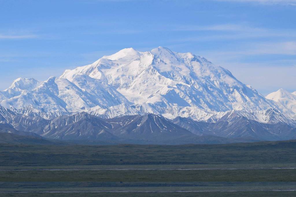
In 1936 and 1937, Washburn took the first large-format aerial photographs of Mt. McKinley. At high altitude and in freezing conditions Washburn and his flight crew used oxygen above 15,000 feet to capture photos of this lofty peak.
This trip led to future expeditions in the 1940s and 1950s that involved first-time achievements in aerial photography, mountaineering and mapping North America’s highest peak. In his work, Washburn summited the mountain three times in 1942, 1947 and 1951.
In 1953, after several years of surveying Denali, Washburn estimated a new height for Denali at 20,320 feet. The current height of 20,310 feet was established in 2015 using the latest GPS survey methods.
Then, in 1960, Washburn produced, for the first time, a detailed topographic map of the mountain known as the “Map of Mt. McKinley.” Many cartographers consider it a masterpiece, and mountaineers and scientists still use it today and will continue to for years to come.
In the 1970s, Washburn and his wife took on another large-scale mapping project. They spent the next seven years surveying and mapping the Grand Canyon. Before he started this survey work, he ordered two sets of aerial photographs from 26,000 feet and 16,000 feet that covered the entire canyon to get an aerial view of the project.
The Washburns spent the next several years surveying the canyon using the latest laser surveying technology and helicopters to access the most remote parts of the canyon. In 1978, National Geographic published the 1:24,000 scale topographic map, and to this day, it is still considered a cartographic work of art among mapmakers.
Washburn never quit exploring, photographing and mapping the wilderness landscapes he loved. In his 70s, he took on one of his final aerial photography and mapping projects that required all the skills, leadership and ingenuity he had acquired over years of leading and organizing remote scientific expeditions.
By the time of this trip in 1980, aerial photography and land surveying technology had advanced considerably since Washburn’s early excursions. This time around, he wanted to capitalize on new technology to map the world’s highest peak, Mt Everest.
After lots of negotiation and planning, he received permission from the governments of Nepal and China to make several photographic mapping flights over the mountain. These high-altitude flights took vertical mapping photos from an altitude of 39,000 feet.
He planned to use aerial photos from those flights and infrared images from the Columbia Space Shuttle (taken 156 miles above the earth) to create a detailed topographic map of Everest. After years of work and with the help of a team of international scientists, the National Geographic Society published one of Washburn’s finest topographic maps.
Using the latest GPS technology at the time, he and his team recalculated a new height for Mt. Everest at 29,035 feet.
Washburn’s career spanned almost a century, and he received numerous awards and honorary doctorates for his scientific accomplishments in Alaska and around the world. You can learn more about Bradford Washburn and his extraordinary expeditions through his National Geographic articles, journals and his autobiography, “Bradford Washburn: An Extraordinary Life.”
Through the early aerial photography and mapping work of explorers and scientists like Bradford Washburn, we continue to use aerial photography and other remote sensing techniques to understand the changing environmental conditions in places like the Kenai National Wildlife Refuge.
In Part III of this series, I will be writing a brief history of how aerial photography and cartography saw considerable technological advancement after the Second World War, and the use of aerial photography and cartography in natural resource management in Alaska.
David Merz is a seasonal biological science technician on the Kenai National Wildlife Refuge who is part of a team using aerial photography and remote sensing to understand changing environmental conditions on the Kenai NWR and throughout Alaska.