Borough opposes DOT Cooper Landing bypass route
Published 4:03 am Friday, September 9, 2016
Several organizations, including the Kenai Peninsula Borough, have come out in opposition to the Alaska Department of Transportation and Public Facilities’ selected route for a highway bypass around Cooper Landing.
Managers of the long-planned highway project, coordinated by DOT and the Federal Highway Administration, are now in the process of preparing a final Environmental Impact Statement before planning construction on a new route for the Sterling Highway, providing an option for drivers to skirt the community of Cooper Landing. Drivers passing through on their way to Kenai or Anchorage have to slow down significantly through the winding river community, where the speed limit is 35 miles per hour and anglers, hikers and residents walk the shoulders on their way to the river or the businesses there.
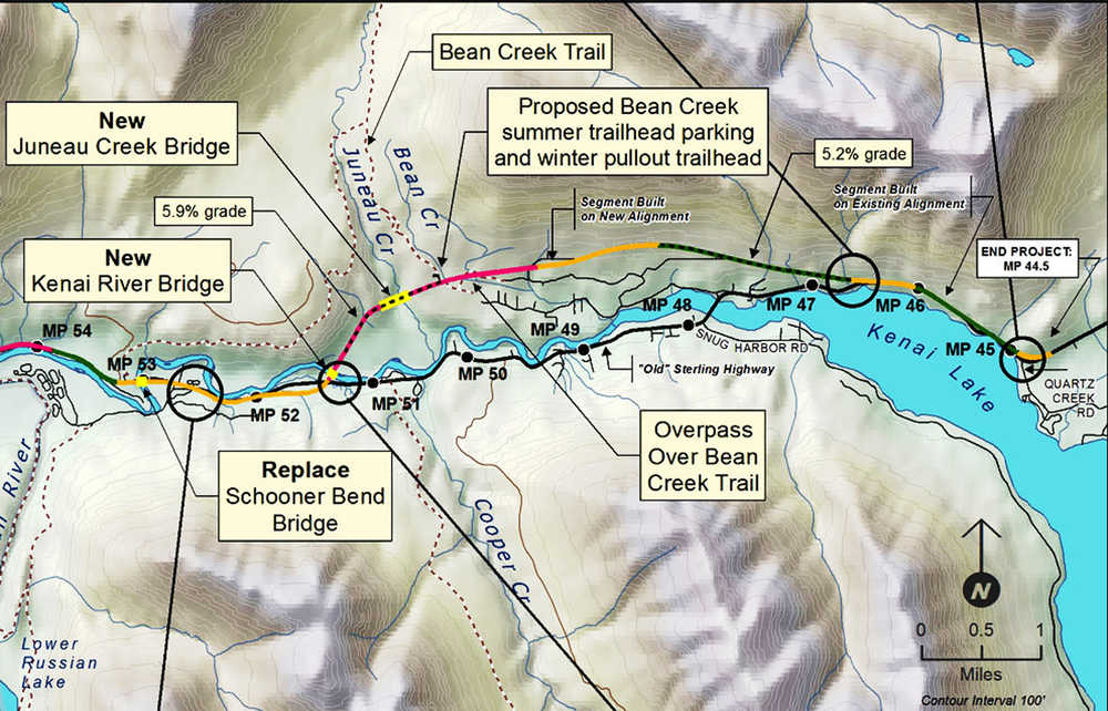
DOT and the Federal Highway Administration identified four routes as options in the spring of 2015 and ultimately selected the G South Alternative in December 2015, which departs the current Sterling Highway around Mile 52 and reconnects with it east of the bridge across Kenai Lake, adding about 5.5 miles of new road and new bridges across the Kenai River and Juneau Creek.
Project managers are preparing the Environmental Impact Statement to send to cooperating agencies within the next month or so, said DOT project manager Kelly Peterson. After the agencies — which include the U.S. Fish and Wildlife Service, the U.S. Forest Service, the U.S. Coast Guard, the Army Corps of Engineers, the Alaska Department of Natural Resources and the Alaska Department of Fish and Game — have had a chance to comment on it, the impact statement will go out to the public, she said.
“We’re looking at getting a final EIS out to the public in the spring,” Peterson said.
The addition of new road and bridges close to the Kenai River has raised concerns.
Each of the alternatives has a different effect on the river, wildlife or recreation, and none of the choices are ideal, wrote Kenai Watershed Forum Executive Director Jack Sinclair in a letter to the borough.
The Kenai Watershed Forum supported a northern route called the Juneau Creek Alternative because it reduces potential hazards for the Kenai River, but also suggested a possible compromise by extending the western end of the G South Route out to Mile 55 to avoid more of the river and eliminate the extra bridge.
“An argument can be made for each one being better than the other depending on how you prioritize brown bear and moose habitat versus fish habitat, or loss of wetlands versus potential water quality degradation, etc.,” he wrote. “The fact is that each alternative will result in negative environmental consequences.”
The proximity to the Kenai River and the additional bridge across it are major concerns because of increased traffic, particularly commercial trucking, said Ricky Gease, executive director of the Kenai River Sportfishing Association. An overturned truck in or near the Kenai River could mean millions of dollars in economic activity and land value lost, as well as damage to the fish habitat in the river, he said.
More important is highway safety — the G South Alternative does not measure up to highway safety standards, nor does it avoid the dangerous curve near Gwin’s Lodge, he said.
“Where is the bottleneck in management planning where we can’t do the route that has been designed and that meets more of the safety standards, the highway safety standards and gets that highway off the Kenai River?” he said.
Peterson said if the plan still includes the curve by Gwin’s Lodge, DOT plans to straighten it out to make it safer.
“If we do build an alternative that goes past Gwin’s Lodge, that curve is going to be fixed,” she said. “We’re going to be widening the road, putting in shoulders, wider lanes … and that curve will be a single curve rather than two curves back to back.”
The borough assembly passed a resolution at its Tuesday meeting supporting the Juneau Creek Alternative, one of the initially proposed routes that would send the reroute north away from the river, with 75 percent of the route being 500 feet or more from the river.
One of the major conflict points is because of land north of the river that carries a wilderness designation, which does not allow development. There is still an option, though, if Alaska Native corporation Cook Inlet Region, Incorporated negotiates a land exchange with the U.S. Fish and Wildlife Service and the U.S. Forest Service.
During its land selection in 1976 through the Alaska Native Claims Settlement Act, CIRI selected some land near the Russian River confluence. A conflict arose between the federal government and the Native corporation because of the high level of public use there during the sockeye salmon run. Negotiations stretched out until 2002, when Congress passed the Russian River Lands Act, authorizing exchanges between CIRI and the federal land managers in the area.
CIRI has indicated an intention to pursue a land exchange in that area, enabling the highway, for some land near the Killey River, which is recognized as early-run Kenai River king salmon and brown bear habitat.
That would enable the northern route without the DOT having to pursue separate approval from Congress to cross wilderness-designated area, Peterson said.
Borough Mayor Mike Navarre said in a Tuesday borough assembly committee meeting the community of Cooper Landing still has doubts about why DOT chose the G South Alternative and wants other options explored. Navarre said CIRI representatives told the borough in a meeting they had chosen not to pursue the land exchange before now because DOT and the Federal Highway Administration had not yet selected a route.
The northern route would also bisect the Resurrection Pass Trail, a 26-mile trail between the small town of Hope and the Sterling Highway near Cooper Landing, about three miles from the southern trailhead.
While some are concerned about cutting through that trail, the road would also provide additional access to the lakes and Juneau Falls if the planners provided offramps there, Navarre said.
“It might make some of those other lakes readily accessible to some folks who otherwise can’t make that trip from the trailhead,” he said.
Peterson said the forthcoming Environmental Impact Statement will evaluate current conditions.
Even if the record of decision, likely to come out in the fall of 2017, includes the G South Alternative, a change in land status could affect that. The Environmental Impact Statement is good for three years without having to renew it, she said.
Reach Elizabeth Earl at elizabeth.earl@cmg-northwest2.go-vip.net/peninsulaclarion.